Ministry of Earth Sciences
updated (at 1500 Hrs. IST)Depression over southeast Bay of Bengal and its likely intensification into a Cyclonic Storm: Pre-cyclone Watch for West Bengal and North Odisha coasts
Posted On:
16 MAY 2020 4:30PM by PIB Delhi
According to the latest updated release (at 1500 Hrs. IST) by the Cyclone Warning Division of the India Meteorological Department:
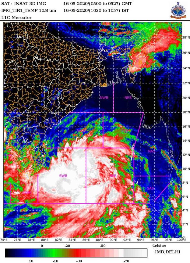
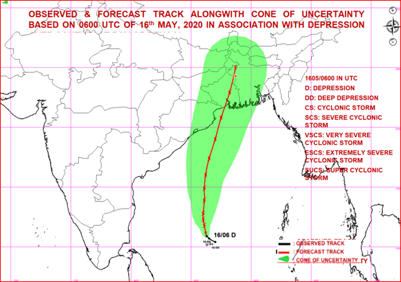
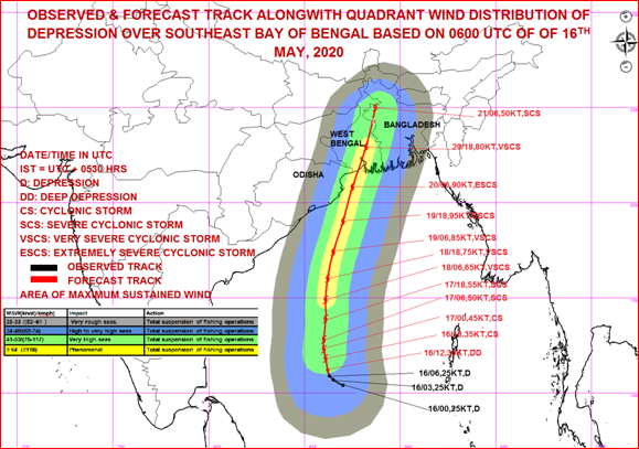
The depression over Southeast Bay of Bengal and neighbourhood moved northwestwards with a speed of 16 kmph during past 06 hours and lay centred at 1130 hrs IST of today, the 16th May, 2020 near latitude 10.9°N and longitude 86.3°E, about 1040 km south of Paradip (Odisha), 1200 km south-southwest of Digha (West Bengal) and 1300 km south-southwest of Khepupara (Bangladesh). It is very likely to intensify into a Cyclonic Storm during next 12 hours and further into a severe cyclonic storm during subsequent 24 hours. It is very likely to move north-northwestwards initially till 17th May and then re-curve north-northeastwardsacross northwest Bay of Bengal towards West Bengal and adjoining Odisha coasts during 18th to 20th May 2020.
Forecast track and intensity are given in the following table:
| Date/Time(IST) |
Position (Lat. 0N/ long. 0E) |
Maximum sustained surface wind speed (Kmph) |
Category of cyclonic disturbance |
| 16.05.20/1130 |
10.9/86.3 |
45-55 gusting to 65 |
Depression
|
| 16.05.20/1730 |
11.2/86.2 |
50-60 gusting to 70 |
Deep Depression
|
| 16.05.20/2330 |
11.8/86.1 |
60-70 gusting to 80 |
Cyclonic Storm
|
| 17.05.20/0530 |
12.3/86.0 |
80-90 gusting to 100 |
Cyclonic Storm
|
| 17.05.20/1130 |
12.8/86.0 |
100-110 gusting to 120 |
Severe Cyclonic Storm
|
| 17.05.20/2330 |
13.9/86.1 |
105-115 gusting to 125 |
Severe Cyclonic Storm
|
| 18.05.20/1130 |
14.9/86.1 |
120-130 gusting to 145 |
Very Severe Cyclonic Storm
|
| 18.05.20/2330 |
16.0/86.2 |
135-145 gusting to 160 |
Very Severe Cyclonic Storm
|
| 19.05.20/1130 |
17.4/86.5 |
155-165 gusting to 180 |
Very Severe Cyclonic Storm
|
| 19.05.20/2330 |
19.0/87.0 |
170-180 gusting to 200 |
Extremely Severe Cyclonic Storm
|
| 20.05.20/1130 |
20.8/87.5 |
160-170 gusting to 190 |
Extremely Severe Cyclonic Storm
|
| 20.05.20/2330 |
22.9/88.2 |
145-155 gusting to 170 |
Very Severe Cyclonic Storm
|
| 21.05.20/1130 |
25.0/88.7 |
110-120 gusting to 135 |
Severe Cyclonic Storm
|
Warnings:
(i) Rainfall (over Andaman & Nicobar Islands):
- Light to moderate rainfall at most places with heavy falls at isolated places is very likely over Andaman & Nicobar Islands on 16th May.
- Rainfall (over Odisha & Gangetic West Bengal)
Coastal Odisha is likely to experience light to moderate rainfall at many places with heavy falls at isolated places from 18th May evening, heavy to very heavy rainfalls at a few places on 19thMay and isolated heavy rainfall over northeast Odisha on 20th May 2020. Coastal districts of Gangetic West Bengal are likely to experience light to moderate rainfall at many places with heavy falls at a few places on 19th May,heavy to very heavy falls at a few places with extremely heavy falls at isolated places over Gangetic West Bengal on 20th May.
(ii) Wind warning
- Squally wind speed reaching 45 to 55 kmph gusting to 65 kmph is likely to commence along and off south Odisha coast from 18th evening, extent over north Odisha coast from 19th morning and along and off West Bengal coast from 19th afternoon. The wind speed will gradually increase becoming gale wind speed reaching 75 to 85 kmph gusting to 95 kmph from 20th morning along and off north Odisha and West Bengal coast. It will gradually increase thereafter.
- Squally wind speed reaching 45 to 55 kmph gusting to 65 kmph is likely over Andaman Sea during next 48 hours.
- Squally wind speed reaching 45 to 55 kmph gusting to 65 kmph is prevailing over southeast and adjoining southwest Bay of Bengal. It is likely to increase becoming 90-100 gusting to 110 kmph over eastcentraland adjoining west central Bay of Bengal by 17th morning, 120-130 gusting to 145 kmph over southern parts of central Bay of Bengal by 18th morning, 155-165 gusting to 180 kmph over northern parts of central Bay of Bengal and adjoining north Bay of Bengal on 19th, and 160-170 gusting to 190 kmph over north Bay of Bengal by 20th morning.
(iii) Sea condition
Sea condition will be rough to very rough over south & adjoining central Bay of Bengal and Andaman Sea till 16th May evening. It will be High over southwest and adjoining central Bay of Bengal from the 16th May night, very high over the same region from 17th morning. It will become phenomenal over southern parts of central Bay of Bengal on 18th, overnorthern parts of central Bay of Bengal and adjoining north Bay of Bengal on 19th May and over north Bay of Bengal on 20th May 2020.
(iv) Fishermen Warning
- The fishermen are advised not to venture into south Bay of Bengal from 16th to 17th May, to central Bay of Bengal 17th to 18thMay and north Bay of Bengal during 19 to 20th May 2020.
- Also, fishermen are advised not to venture into north Bay of Bengalalong and off North Odisha, West Bengal and adjoining Bangladesh coast during 18th to 20th May 2020.
Kindly visitwww.rsmcnewdelhi.imd.gov.in and www.mausam.imd.gov.in for updates on the system.
(Pl see pix below)……..
****
KGS/(IMD release)
(Release ID: 1624291)
Visitor Counter : 1523