Ministry of Science & Technology
National Geospatial Policy 2022
“Powering India’s Vision for Viksit Bharat”
प्रविष्टि तिथि:
27 FEB 2025 1:22PM by PIB Delhi
|
“The democratization of Indian geospatial ecosystem will spur domestic innovation and enable Indian companies to compete in the global mapping ecosystem by leveraging modern geospatial technologies and realising the dream of ‘Atmanirbhar Bharat’ fully.
-Dr Jitendra Singh, Union Minister of State (Independent Charge) Ministry of Science and Technology
|
Introduction
The National Geospatial Policy, 2022, notified by the Government of India on December 28, 2022, is a transformative policy aimed at positioning India as a global leader in the geospatial sector. With a long-term vision extending to 2035, the policy seeks to liberalize and democratize access to geospatial data, fostering innovation and enabling its widespread use across governance, businesses, and academia.
At its core, the policy is citizen-centric, ensuring that geospatial datasets generated with public funds are openly accessible. It outlines a strategic roadmap for the development of geospatial infrastructure, services, and platforms at both national and sub-national levels. One of its key goals is to establish a high-resolution topographical survey and mapping system by 2030, alongside a highly accurate Digital Elevation Model (DEM) for the entire country.
Recognizing the importance of geospatial technology in governance, economic growth, and societal development, the policy focuses on strengthening institutional frameworks, enhancing national and state-level coordination, and fostering a vibrant geospatial ecosystem. The Department of Science and Technology (DST) plays a pivotal role in this effort by promoting the reuse and open access of geospatial data, products, and services through a network of geospatial platforms.
By creating an enabling environment for geospatial technology adoption, the policy is expected to drive advancements in urban planning, disaster management, agriculture, environmental conservation, transportation, and various other sectors. This article examines the National Geospatial Policy 2022, focusing on its alignment with PM Gati Shakti, budgetary allocations, the National Geospatial Data Repository, and Operation Dronagiri’s impact on innovation. It also explores how the policy fosters inclusion, economic growth, and private sector participation, ensuring geospatial intelligence enhances governance, business, and public services across India.
Recent Allocations and Trends from the Union Budget 2025
In the Union Budget for the fiscal year 2025-26, the government has reinforced its commitment to the geospatial sector:
- Government of India has allocated ₹100 crore for the National Geospatial Mission. This mission aims to develop foundational geospatial infrastructure and data, playing a crucial role in modernizing land records, urban planning, and infrastructure design. By leveraging PM Gati Shakti, the initiative will facilitate integrated planning, enhance data-driven decision-making, and improve the efficiency of infrastructure projects across the country. This strategic investment underscores the government’s focus on harnessing geospatial technology for economic growth, governance, and sustainable development.
- To enhance public-private partnerships (PPPs) and support the private sector in project planning, access to relevant geospatial data and maps from the PM Gati Shakti portal will be made available. This initiative aims to streamline infrastructure development, improve decision-making, and foster greater collaboration between the government and private enterprises.
Vision of the National Geospatial Policy
To position India as a global leader in the geospatial sector by fostering a world-class innovation ecosystem, leveraging geospatial technology for economic growth, and ensuring easy access to valuable geospatial data for businesses and citizens.
Goals of the National Geospatial Policy
By 2025
- Establish an enabling policy and legal framework to support the liberalization of the geospatial sector and democratization of data.
- Enhance availability and accessibility of high-quality location data across sectors to drive innovation and enterprise.
- Develop a unified digital interface for accessing geospatial data collected through public funds.
- Redefine the National Geodetic Framework using modern positioning technologies, with online accessibility.
- Create a high-accuracy geoid model for the entire country.
- Strengthen national and sub-national geospatial governance by fostering collaboration between the government, private sector, academia, and civil society.
By 2030
- Conduct high-resolution topographical surveys (5–10 cm for urban/rural areas and 50–100 cm for forests/wastelands).
- Develop a high-accuracy Digital Elevation Model (DEM) (25 cm for plains, 1–3 m for hilly/mountainous areas).
- Establish a Geospatial Knowledge Infrastructure (GKI) underpinned by an Integrated Data and Information Framework.
- Enhance geospatial skills, capabilities, and awareness to meet future technological and economic demands.
By 2035
- Generate high-resolution bathymetric geospatial data for inland waters and deep-sea topography to support the Blue Economy.
- Survey and map sub-surface infrastructure in major cities and towns.
- Develop a National Digital Twin for major urban centers, creating digital replicas to improve urban planning and management.
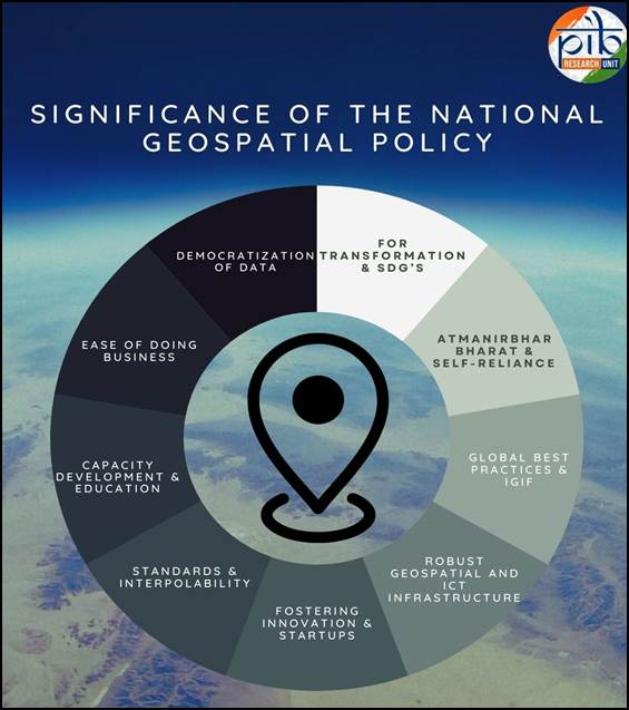
Key Focus Areas of the National Geospatial Policy, 2022
- Geospatial for Transformation & SDGs – The policy positions geospatial technology and data as key drivers for achieving Sustainable Development Goals (SDGs), enhancing efficiency across sectors, and ensuring transparency in governance.
- Atmanirbhar Bharat & Self-Reliance – Recognizing the need for locally relevant geospatial data, the policy aims to foster a self-reliant geospatial ecosystem, empowering Indian companies to compete globally and reduce dependency on foreign providers.
- Global Best Practices & IGIF – Adopting international frameworks like the Integrated Geospatial Information Framework (IGIF) under UN-GGIM, the policy strengthens India's national spatial information management.
- Robust Geospatial & ICT Infrastructure – Establishing a well-defined data custodianship model to ensure the collection, management, and real-time accessibility of high-quality geospatial data for cross-sector collaboration.
- Fostering Innovation & Startups – Encouraging startups, R&D, and emerging technologies, the policy promotes regulatory modernization and bridges the geospatial digital divide.
- Standards & Interoperability – Advocating open standards, open data, and compliance frameworks, the policy ensures seamless integration and interoperability of geospatial information.
- Capacity Development & Education – Promoting geospatial education from school levels, alongside standardized certifications and skill development programs to sustain long-term industry growth.
- Ease of Doing Business – Continued policy liberalization to attract investment, facilitate business-friendly regulations, and support geospatial enterprises.
- Democratization of Data – Survey of India (SoI) and other publicly funded geospatial data will be treated as a public good, ensuring easy access and utilization for all stakeholders.
Geospatial Policy Under PM Gati Shakti
The National Geospatial Policy (NGP) 2022 is closely aligned with the PM Gati Shakti – National Master Plan for Multi-modal Connectivity, a digital platform launched by the Prime Minister to integrate 16 key Ministries, including Railways and Roadways, for coordinated infrastructure planning and implementation. The initiative aims to facilitate seamless multi-modal connectivity for the movement of people, goods, and services across different modes of transport, ensuring last-mile connectivity and reducing travel time. By leveraging accurate, real-time geospatial data, NGP 2022 plays a critical role in streamlining infrastructure projects, minimizing redundancies, and optimizing resource utilization.

PM Gati Shakti seeks to integrate infrastructure schemes across various Ministries and State Governments. A key aspect of this initiative is the extensive use of geospatial technology, including spatial planning tools developed by ISRO and BiSAG-N. This integration enhances data-driven decision-making for efficient infrastructure development and economic growth.
National Geospatial Data Repository: A Step Towards Seamless Data Integration
The National Geospatial Data Repository is being developed to serve as a centralized platform for geospatial data management and access. This repository will consolidate geospatial datasets from various government and private entities, ensuring seamless data sharing, interoperability, and accessibility across multiple sectors.

With the increasing demand for precise and real-time geospatial intelligence, this repository will act as a critical resource for improving governance, boosting economic development, and advancing digital infrastructure. It aligns with the National Geospatial Policy 2022, reinforcing India's commitment to leveraging geospatial technology for sustainable growth and enhanced citizen services.
Operation Dronagiri: Transforming India's Geospatial Landscape
Launch and Overview
Operation Dronagiri, launched on November 13, 2024, is a pilot initiative under the National Geospatial Policy 2022. The project aims to demonstrate the real-world applications of geospatial technologies to enhance citizen services, business efficiency, and governance. It is designed to integrate geospatial data, analytics, and advanced mapping technologies to support multiple sectors.
Components and Implementation
In its initial phase, Operation Dronagiri is being implemented in five states—Uttar Pradesh, Haryana, Assam, Andhra Pradesh, and Maharashtra.
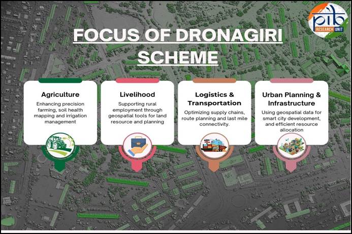
The project brings together government departments, industry partners, corporations, and startups to drive geospatial innovation and ensure efficient utilization of spatial data.
Integrated Geospatial Data Sharing Interface (GDI)
A key feature of Operation Dronagiri is the development of an Integrated Geospatial Data Sharing Interface (GDI), which:
- Facilitates seamless access and sharing of geospatial data across different sectors.
- Supports applications in urban planning, environmental monitoring, and disaster management.
- Helps organizations make data-driven decisions for public welfare.
Impact and Future Expansion
The initiative is expected to enhance governance, boost economic efficiency, and promote sustainable infrastructure development. By integrating geospatial technologies with public and private sector initiatives, Operation Dronagiri envisions a nationwide rollout under a Public-Private Partnership (PPP) model.
With India’s growing emphasis on geospatial intelligence, the project aims to transform infrastructure planning, improve disaster response, and foster innovation in geospatial applications—paving the way for a data-driven and technologically advanced India.
Empowering Inclusion and Progress: National Geospatial Policy 2022 in Action
The National Geospatial Policy 2022 (NGP 2022) underscores the Government of India’s commitment to inclusive development by significantly expanding access to geospatial data and related services. By democratizing location-based data, the policy has enhanced citizen services, improved governance, and extended its benefits to even the most remote areas of the country.
To implement NGP 2022, the Department of Science and Technology (DST) has strengthened the governance framework to liberalize geospatial data access. Emphasizing the Atmanirbhar Bharat vision, DST is fostering self-reliance in geospatial technology by empowering Indian enterprises to generate, utilize, and commercialize their own geospatial data—enhancing their global competitiveness. The policy further encourages the adoption of open standards, open data, and interoperable platforms to enable seamless collaboration across stakeholders.
To further enhance geospatial infrastructure, the Survey of India (SoI) has launched a pan-India Continuously Operating Reference Stations (CORS) Network, ensuring high-accuracy location data. Additionally, under the SVAMITVA Scheme, SoI has surveyed and mapped over 2.8 lakh villages across Andhra Pradesh, Haryana, and Karnataka using drone technology, streamlining land records and property rights.
NGP 2022 is fostering a thriving geospatial industry by encouraging private sector participation. Individuals, companies, and government agencies can now process, build applications, and develop solutions using geospatial data. The promotion of open standards, open data, and geospatial platforms has enabled enterprise development and innovation, further solidifying India’s position as a global leader in geospatial technology. To support technological innovation and entrepreneurship, the policy is facilitating the establishment of incubation centers, industry accelerators, and Geospatial Technology Parks. These initiatives are driving research, fostering startups, and strengthening India’s geospatial ecosystem, ultimately positioning the country as a world leader in geospatial innovation.
With its focus on expanding access, promoting innovation, and leveraging geospatial intelligence, NGP 2022 is not just a policy—it is a transformative tool for national development, economic prosperity, and a thriving digital economy. It is a key driver in realizing the Prime Minister’s vision of Viksit Bharat (Developed India), paving the way for a future driven by geospatial intelligence and data-led governance.
Conclusion
The National Geospatial Policy 2022 is a significant step towards strengthening India's geospatial ecosystem. By simplifying data access, promoting innovation, and fostering enterprise development, the policy is creating a robust and dynamic geospatial sector that supports governance, industry, and research.With initiatives like PM Gati Shakti, the National Geospatial Data Repository, and Operation Dronagiri, the policy is driving data-driven decision-making, infrastructure modernization, and digital transformation. As India advances towards Viksit Bharat, geospatial intelligence will be central to planning, connectivity, and national resilience. The National Geospatial Policy 2022 positions India as a global leader in geospatial technology, ensuring that location-based intelligence powers the nation's progress and prosperity.
References
Click here to see PDF:
Santosh Kumar/ Sheetal Angral/ Vatsla Srivastava
(रिलीज़ आईडी: 2106569)
आगंतुक पटल : 10098