Ministry of Earth Sciences
Tracking Severe Cyclonic Storm ‘AMPHAN’ (at 2030 Hrs IST)
Posted On:
17 MAY 2020 10:00PM by PIB Delhi
According to the latestrelease (at 2030 Hrs. IST)by the National Weather Forecasting Centre/Cyclone Warning Division of the India Meteorological Department:
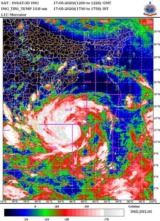
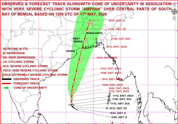
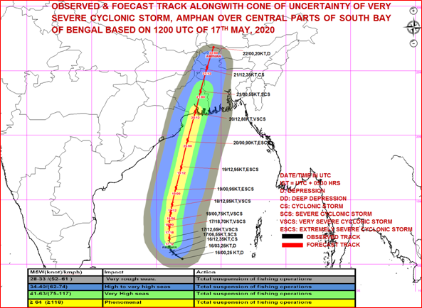
The Very Severe Cyclonic Storm‘AMPHAN’ (pronounced as UM-PUN) over central parts of SouthBay of Bengal moved northwards with a speed of 09 kmph during past 06 hours and lay centred at 1730 hrs IST of today, the 17th May, 2020 over central parts of South Bay of Bengal near latitude 12.0°N and longitude 86.0°E, about 930 km south of Paradip (Odisha), 1080 km south-southwest of Digha (West Bengal) and 1200 km south-southwest of Khepupara (Bangladesh). It is very likely to intensify further into an Extremely Severe Cyclonic Storm during next 24 hours. It is very likely to move nearly northwards slowly during next 12 hours and then re-curve north-northeastwards and move fast across northwest Bay of Bengal and cross West Bengal – Bangladesh coasts between Digha (West Bengal) and Hatiya Islands (Bangladesh) during the Afternoon / Evening of 20th May 2020 as a Very Severe Cyclonic Storm.
Forecast track and intensity are given in the following table:
| Date/Time(IST) |
Position (Lat. 0N/ long. 0E) |
Maximum sustained surface wind speed (Kmph) |
Category of cyclonic disturbance |
| 17.05.20/1730 |
12.0/86.0 |
125-135 gusting to 150 |
Very Severe Cyclonic Storm
|
| 17.05.20/2330 |
12.9/86.0 |
135-145 gusting to 160 |
Very Severe Cyclonic Storm
|
| 18.05.20/0530 |
13.5/86.0 |
140-150 gusting to 165 |
Very Severe Cyclonic Storm
|
| 18.05.20/1130 |
14.0/86.1 |
150-160 gusting to 170 |
Very Severe Cyclonic Storm
|
| 18.05.20/1730 |
14.6/86.2 |
160-170 gusting to 185 |
Extremely Severe Cyclonic Storm
|
| 19.05.20/0530 |
15.9/86.5 |
170-180 gusting to 200 |
Extremely Severe Cyclonic Storm
|
| 19.05.20/1730 |
17.5/86.9 |
170-180 gusting to 200 |
Extremely Severe Cyclonic Storm
|
| 20.05.20/0530 |
19.6/87.4 |
160-170 gusting to 190 |
Extremely Severe Cyclonic Storm
|
| 20.05.20/1730 |
21.8/88.0 |
145-155 gusting to 170 |
Very Severe Cyclonic Storm
|
| 21.05.20/0530 |
23.4/88.4 |
95-105 gusting to 115 |
Severe Cyclonic Storm
|
| 21.05.20/1730 |
25.2/88.9 |
60-70 gusting to 80 |
Cyclonic Storm
|
| 22.05.20/0530 |
26.8/89.4 |
30-40 gusting to 50 |
Depression
|
(1) Heavy rainfall Warning:
Odisha
Coastal Odisha is likely to experience light to moderate rainfall at many places with heavy falls at isolated places from 18th May evening. Rainfall at most places with heavy to very heavy rainfall at a few places over north coastal Odisha (Jagatsinghpur, Kendrapara, Jajpur, Bhadrak, Balasore& Mayurbhanj Districts) on 19thMay and isolated heavy rainfall over north coastal Odisha (Bhadrak, Balasore& Mayurbhanj Districts) on 20th May 2020.
West Bengal
Coastal districts of Gangetic West Bengal (East Medinipur, South & North 24 Parganas) are likely to experience light to moderate rainfall at many places with heavy falls at isolated places on 19th May. Rainfall at most places with heavy to very heavy falls at a few places & extremely heavy falls at isolated places likely over Gangetic West Bengal (east & west Medinipur, south & north 24 Parganas, Howrah, Hoogli, Kolkata and adjoining districts)on 20th May.
(2) Wind warning
West Bengal &Odisha
- Squally wind speed reaching 45 to 55 kmph gusting to 65 kmph is likely to commence along and off south Odisha coast from 18th evening, extend to along & off north Odisha coast from 19th morning and along and off West Bengal coast from 19th afternoon.
- The wind speed will gradually increase becoming gale wind speed reaching 75 to 85 kmph gusting to 95 kmph from 20th morning along and off north Odisha (Jagatsinghpur, Kendrapara, Bhadrak, Balasore and Mayurbhanj districts) and West Bengal (east & west Medinipur, south & north 24 Parganas, Howrah, Hoogli, Kolkata Districts). It will gradually increase thereafter becoming 110 to 120 kmph gusting to 135 kmph along & off the above mentioned districts of North Odisha and 120 to 140 kmph gusting to 155 kmph along & off the above districts of West Bengal from the afternoon of 20th May 2020.
- Squally wind speed reaching 55-65 kmph gusting to 75 kmph likely to prevail over Puri, Khordha, Cuttack, Jajpur districts of Odisha during 20th May 2020.
Deep Sea area
- Gale wind speed reaching 125-135 gusting to 150 kmph is prevailing over southeast and adjoining southwest Bay of Bengal. It is likely to increase becoming 140-150 gusting to 165 kmph over southern parts of central Bay of Bengal by 18th morning, 170-180 gusting to 200 kmph over northern parts of central Bay of Bengal and adjoining North Bay of Bengal on 19th, and 155-165 gusting to 180 kmph over north Bay of Bengal during 20th May.
(3) Sea condition
Sea condition will be Phenomenal over central parts of south Bay of Bengal and adjoining central Bay of Bengal during next 24 hours. It will become Phenomenal over southern parts of central Bay of Bengal from tonight, overnorthern parts of central Bay of Bengal and adjoining north Bay of Bengal on 19th May and over north Bay of Bengal on 20th May 2020.
(4) Fishermen Warning
- The fishermen are advised not to venture into south Bay of Bengalduring next 24 hours, to central Bay of Bengalduring 17th to 18thMay and into North Bay of Bengal during 18th to 20th May 2020.
- Also, fishermen are advised not to venture into north Bay of Bengalalong and off North Odisha, West Bengal and adjoining Bangladesh coasts during 18th to 20th May 2020.
(5)Storm Surge expected
- Storm Surge of about 3-4 meters above Astronomical Tide is likely to inundate low lying areas of south & north 24 Parganas and 2-3 meters over the low lying areas of East Medinipur District of West Bengal around the time of Landfall.
(6)Damage Expected and Action suggested
(a) West Bengal(east Medinipur, south & north 24 Parganas, Howrah, Hoogli, Kolkata districts)
Damage Expected:
- Extensive damage to all types of kutcha houses, some damage to old badly managed Pucca structures. Potential threat from flying objects.
- Extensive uprooting of communication and power poles.
- Disruption of rail/road link at several places.
- Extensive damage to standing crops, plantations, orchards.
- Blowing down of Palm and coconut trees.
- Uprooting of large bushy trees.
- Large boats and ships may get torn from their moorings.
Fishermen Warning & Action Suggested:
- Total suspension of fishing operations during 18th to 20th May 2020.
- Diversion or suspension of rail and road traffic.
- People in affected areas to remain indoors.Mobilise evacuation from Low lying areas.
- Movement in motor boats and small ships not advisable.
(b) Odisha (Jagatsinghpur,Kendrapara, Bhadrak, Balasore, Jajpur& Mayurbhanj)
Damage Expected:
- Total destruction of thatched houses/ extensive damage to kutcha houses. Some damage to pucca houses. Potential threat from flying objects.
- Bending/ uprooting of power and communication poles.
- Major damage to Kutcha and Pucca roads. Minor disruption of railways, overhead power lines and signalling systems.
- Widespread damage to standing crops, plantations, orchards, falling of green coconuts and tearing of palm fronds. Blowing down of bushy trees like mango.
- Small boats, country crafts may get detached from moorings.
Fishermen Warning & Action Suggested:
- Total suspension of fishing operations along & off Odisha coast during 18th to 20th May 2020.
- Judicious regulation of rail and road traffic.
- People in affected areas to remain indoors.
- Movement in motor boats and small ships unsafe.
- Small Fishing Boats may get detached and damaged from their moorings.
Kindly visitwww.rsmcnewdelhi.imd.gov.in and www.mausam.imd.gov.in for updates on the system.
(See pix below)


****
KGS/(IMD release)
(Release ID: 1624790)
Visitor Counter : 1789