Ministry of Panchayati Raj
Building a Self-Reliant India
5 Years of SVAMITVA Scheme
प्रविष्टि तिथि:
23 APR 2025 5:56PM by PIB Delhi
“The country is determined to make the villages and the poor self-reliant, to realize the potential of India. The role of SVAMITVA Scheme is very big for the accomplishment of this resolution.”
~ Prime Minister Narendra Modi
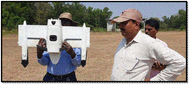
- Launched in April 2020, SVAMITVA provides legal ownership of rural residential land using drone-based surveys.
- SVAMITVA was implemented by the Ministry of Panchayati Raj with support from Survey of India and National Informatics Centre Services Inc. (NICSI).
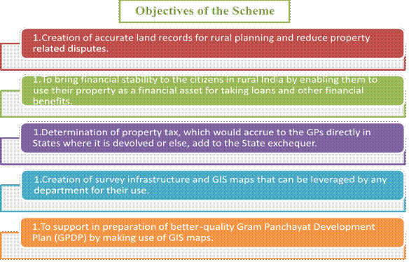
- It aims to empower rural citizens with property cards, enabling access to credit, dispute resolution, and better planning.
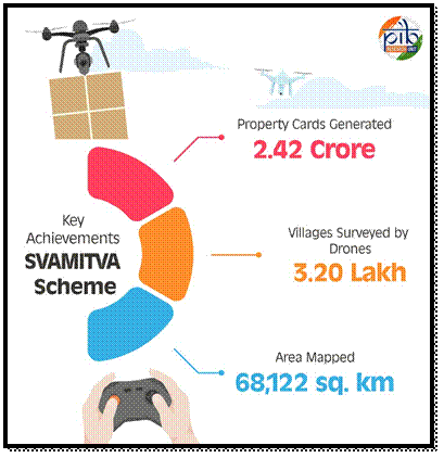
- Over 2.42 crore property cards have been created for 1.61 lakh villages under the scheme.
- Drone surveys completed in 3.20 lakh villages, covering 68,122 sq. km of the area.
SVAMITVA is transforming rural governance, boosting economic growth and showcasing India’s land tech globally.
Introduction
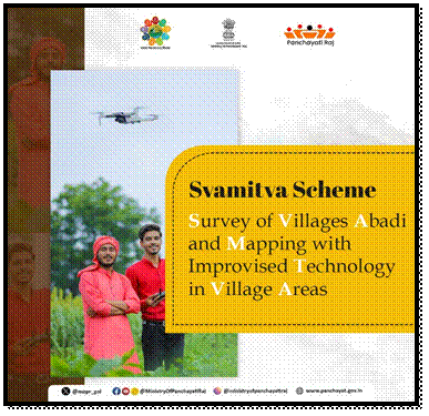
The SVAMITVA (Survey of Villages and Mapping with Improvised Technology in Village Areas) Scheme was launched by the Prime Minister on April 24, 2020, on National Panchayati Raj Day. This year, SVAMITVA is celebrating its 5th anniversary! The scheme helps people in villages get legal ownership papers for the houses and land they live on. It uses drones and special mapping tools to clearly mark property boundaries. With these papers, people can take bank loans, settle land disputes, and even use their property to earn more. It also helps in better village planning.
The SVAMITVA Scheme is implemented by the Survey of India (SoI) with the National Informatics Centre Services Inc. (NICSI) as the technology partner. The total cost is ₹566.23 crores from Financial Year (FY) 2020-21 to FY 2024-25, with an extension until FY 2025-26.
Key Achievements Under Scheme
- On 18th January 2025, 65 lakh SVAMITVA property cards were distributed across more than 50,000 villages in 10 States (Chhattisgarh, Gujarat, Himachal Pradesh, Madhya Pradesh, Maharashtra, Mizoram, Odisha, Punjab, Rajasthan, Uttar Pradesh) and 2 Union Territories (Jammu & Kashmir and Ladakh).
- As of 2nd April 2025, drone surveys have been completed in 3.20 lakh villages under the SVAMITVA Scheme. These surveys have covered an estimated area of 68,122 square kilometers, based on the average size of the inhabited areas in each village.
- As of 11th March 2025, 31 States and Union Territories have signed Memorandums of Understanding (MoUs). Drone surveys have been completed in 3.20 lakh villages, with full coverage in the Union Territories of Lakshadweep, Ladakh, Delhi and the states of Andhra Pradesh, Madhya Pradesh, Uttar Pradesh, and Chhattisgarh. A total of 2.42 crore property cards have been issued for 1.61 lakh villages.
SVAMITVA: Inspiring Global Land Governance Innovations
SVAMITVA is setting a global example by using technology to transform land governance and inspire other countries to adopt similar models.
- The International Workshop on Land Governance held from March 24-29, 2025, at Haryana Institute of Public Administration (HIPA), Gurugram, brought together senior officials from 22 countries. The event showcased India’s innovative approach, including drone-based surveys, digital property records and transparent governance through the SVAMITVA Scheme.
- At the India International Trade Fair 2024 in Bharat Mandapam, the scheme demonstrated how drones and GIS mapping are helping rural communities gain clear and legal land ownership. This not only reduces disputes but also improves access to credit and fosters economic growth, empowering rural India and enhancing property rights.
Need for SVAMITVA
For decades, many village homes and lands in India were never properly recorded. Without legal documents, people couldn’t prove ownership or use their property to get bank loans or government help. This lack of records slowed down the economic growth of rural areas and led to frequent land disputes. To solve this, the SVAMITVA Scheme gives people legal ownership papers, helping them secure their rights and build a better future.

SVAMITVA Components
The SVAMITVA Scheme is built on key components that ensure accurate land mapping, efficient implementation, and community awareness:
- Establishment of Continuously Operating Reference Stations (CORS) network: The CORS network support in establishing Ground Control Points, which is an important activity for accurate Geo-referencing, ground truthing and demarcation of Lands.
- Large Scale Mapping using Drones: Rural inhabited (abadi) area is being mapping by Survey of India using drone Survey. It generates high resolution and accurate maps to confer ownership property rights. Based on these maps or data, property cards issue to the rural household owners.
- Information, Education, and Communication (IEC) Initiatives: Awareness program to sensitize the local population about the scheme methodology and its benefits.
- Enhancement of Spatial Planning Application “Gram Manchitra”: Leveraging digital spatial data/maps created under drone survey for creation of spatial analytical tools to support preparation of Gram Panchayat Development Plan (GPDP).
- Online Monitoring System: Online Monitoring and reporting dashboard is monitored to track the progress of activities.
- Project Management: Programme Management Units at the National and State levels for supporting Ministry & State respectively with scheme implementation.
Success Stories
The SVAMITVA Scheme is transforming rural governance by providing clear property rights and improving land management. These examples underscore the scheme's role in driving rural progress and fostering self-reliance.
- Dispute Resolution: After 25 years of uncertainty, Smt. Sunita from Taropka village in Himachal Pradesh got legal ownership of her ancestral land through the SVAMITVA Scheme. With her property card, she settled a long-standing dispute with her neighbor, bringing peace and security to her family’s future. The SVAMITVA Scheme gave her clear ownership, improving her life.
- Financial Inclusion: Sh. Sukhlal Pargi from Falated village in Rajasthan received a Patta and Property Card through the SVAMITVA Scheme. With these documents, he was able to access financial services. He used the property card to get a bank loan of Rs 3 lakh quickly. The SVAMITVA Scheme gave him legal ownership and helped improve his financial stability.
Conclusion
The SVAMITVA Scheme is changing land ownership in rural India. It turns old challenges into new opportunities for growth and empowerment. The scheme uses technology to solve disputes and break barriers. It helps people use their land for economic progress. With drones and digital property cards, it’s about creating new possibilities. SVAMITVA is more than a government program, it’s a step toward self-reliance, better planning and a stronger rural India.
References
- Ministry of Panchayati Raj
https://static.pib.gov.in/WriteReadData/specificdocs/documents/2022/jun/doc20226862301.pdf
Click here to download PDF
******
Santosh Kumar/ Sarla Meena/ Kamna Lakaria
(रिलीज़ आईडी: 2123886)
आगंतुक पटल : 6137