भूविज्ञान मंत्रालय
नैऋत्य मोसमी पावसाची पुढील वाटचाल दक्षिण अरबी समुद्राचा उर्वरित भाग, मध्य अरबी समुद्राचा काही भाग, केरळ आणि लक्षद्वीपच्या उर्वरित भागात होण्याची शक्यता
Posted On:
04 JUN 2021 3:20PM by PIB Mumbai
नवी दिल्ली, 4 जून 2021
भारतीय हवामानशास्त्र विभाग (आयएमडी) च्या राष्ट्रीय हवामान अंदाज केंद्रानुसार:
(शुक्रवार 4 जून 2021,सकाळ, जारी होण्याची वेळ: भारतीय प्रमाणवेळ 0800 वाजता)
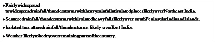
अखिल भारतीय हवामान सारांश आणि अंदाज
आगामी 5 दिवसाच्या कालावधीसाठी हवामानाचा इशारा
4 जून (दिवस पहिला ): ♦ मेघगर्जनेसह विजांचा कडकडाट आणि वादळी वारे (30-40 किमी प्रतितास वेगाने )
विदर्भ, मध्य महाराष्ट्र , मराठवाडा , कोकण आणि गोव्याच्या तुरळक भागात मेघगर्जनेसह विजांचा कडकडाट आणि वादळी वारे वाहण्याची शक्यता
♦ मध्य महाराष्ट्र , कोकण आणि गोव्यात तुरळक ठिकाणी मुसळधार पावसाची शक्यता
5 जून (दुसरा दिवस ):♦ मेघगर्जनेसह विजांचा कडकडाट आणि वादळी वारे (30-40 किमी प्रतितास वेगाने )
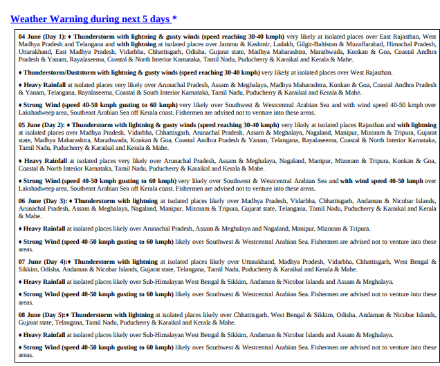
विदर्भ, मध्य महाराष्ट्र , मराठवाडा , कोकण आणि गोव्याच्या तुरळक भागात मेघगर्जनेसह विजांचा कडकडाट आणि वादळी वारे वाहण्याची शक्यता
♦ कोकण आणि गोव्यात तुरळक ठिकाणी मुसळधार पावसाची शक्यता
6 जून (तिसरा दिवस ): ♦ मेघगर्जनेसह विजांचा कडकडाट
विदर्भात तुरळक ठिकाणी मेघगर्जना आणि विजांच्या कडकडाटाची शक्यता
7 जून (चौथा दिवस ) ♦ मेघगर्जनेसह विजांचा कडकडाट
विदर्भात तुरळक ठिकाणी मेघगर्जना आणि विजांच्या कडकडाटाची शक्यता
8 जून (पाचवा दिवस ):♦ ♦ मेघगर्जनेसह विजांचा कडकडाट
महाराष्ट्र आणि गोव्यात होण्याची शक्यता नाही
(तपशील आणि ग्राफिक्ससाठी कृपया येथे क्लिक करा)
* * *
Jaydevi PS/S.Chavan/D.Rane
सोशल मिडियावर आम्हाला फॉलो करा:  @PIBMumbai
  /PIBMumbai
  /pibmumbai
  pibmumbai[at]gmail[dot]com
(Release ID: 1724405)
अभ्यागत कक्ष : 166