Ministry of Earth Sciences
All India Weather Forecast (updated 2030 Hrs. IST)
प्रविष्टि तिथि:
17 MAY 2020 9:51PM by PIB Delhi
According to the latestrelease (at 2030 Hrs. IST)by the National Weather Forecasting Centre/Cyclone Warning Divisionof the India Meteorological Department:
♦ The Very Severe Cyclonic storm " AMPHAN" ( pronounced as UMPUN) over central parts of South Bay of Bengal movednorthtwards with a speed of 09 kmph during past 06 hours and lay centred at 1730 hrs IST of today, the 17th May, 2020 over centralparts of South Bay of Bengal near latitude 12.0°N and longitude 86.0°E, about 930 km south of Paradip (Odisha), 1080 km south-southwest of Digha (West Bengal) and 1200 km southsouthwest of Khepupara (Bangladesh). It is very likely to intensify further intoan Extremely Severe Cyclonic Storm during next 24 hours. It is very likely to move nearly northwards slowly during next 12 hoursand then recurve northnortheastwards and move fast across northwest Bay of Bengal and cross West Bengal Bangladesh coastsbetween Digha (West Bengal) and Hatiya Islands (Bangladesh) during Afternoon/Evening of 20th May 2020 as a Very SevereCyclonic Storm.
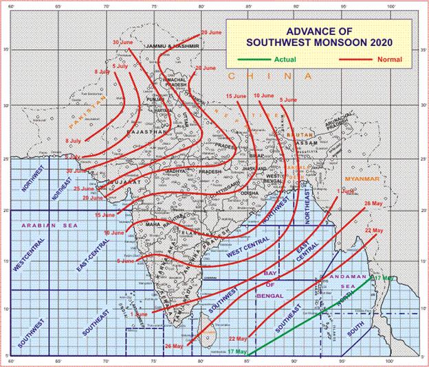
♦ The Southwest Monsoon has advanced into some parts of south Bay of Bengal, Nicobar Islands & Andaman Sea. ♦ The Northern Limit of Monsoon( NLM) passes through Lat.5°N/Long.85°E, Lat.8°N/Long.90°E, Car Nicobar,Lat.11°N/Long.95°E.
♦ Conditions are favourable for further advance of Southwest Monsoon into some more parts of south Bay of Bengal, remainingparts of Andaman Sea and Andaman Islands and some parts of eastcentral Bay of Bengal during next 48 hours.
♦ The Western Disturbance as a trough in midtropospheric westerlies with its axis at 5.8 km above mean sea level now runs roughlyalong Longitude 69°E to the north of latitude 28°N.
♦ The cyclonic circulation over East Pakistan and adjoining West Rajasthan at 0.9 km above mean sea level persists.
♦ The cyclonic circulation extending upto 0.9 km above mean sea level over east Bangladesh & adjoining Meghalaya persists.
♦ The trough from SubHimalayan West Bengal to the above cyclonic circulation over east Bangladesh & adjoining Meghalayaextending upto 0.9 km above mean sea level persists.
♦ The cyclonic circulation between 3.6 km & 4.5 km above mean sea level over southeast Arabian Sea off Kerala coast persists.
Due to likely northwesterly winds at lower levels & dry weather over most parts of northwest, central and Gujarat fromtomorrow onwards; heat wave very likely to occur over Rajasthan, Gujarat state & West Madhya Pradesh during 19-21 May;over East Madhya Pradesh &Vidharbha on 21st & 22nd May, 2020.
Weather Forecast for next 5 days * upto 0830 hours IST of 22nd May, 2020
♦ Maximum Temperatures likely to remain between 40-43°C over some parts of Tamilnadu, Telangana,Rayalaseema and North Interior Karnataka during next 2 days. Maximum temperatures likely to risegradually by 2-4°C over plains of Northwest & adjoining Central India during next 3 days.
♦ No significant change in maximum temperatures likely over rest parts of the country during next 2days.
Weather Outlook for subsequent 2 days from 22nd May, 2020 to 24th May, 2020
♦ Fairly widespread to widespread rain/ thundershowers likely over Islands, northeast India & adjoiningparts of East India. Isolated heavy rainfall is also likely over northeast India.
♦ Isolated to scattered rain/ thundershowers likely over parts of south peninsular India.
♦ Dry weather likely to prevail over the remaining parts of the country.
♦Above normal temperature are likely over many pockets of plains of northwest, central & west India.
Heat wave at isolated pockets are very likely over above regions.
****
KGS/(IMD release
(रिलीज़ आईडी: 1624788)
आगंतुक पटल : 980