Energy & Environment
The Indian Monsoon
Nature’s Pulse and Nation’s Lifeline
Posted On:
15 JUL 2025 11:27AM
Introduction
The monsoon is more than just a season of rain for India. This unique and powerful climate system is a lifeline for the people of the country, with wide ranging, direct and indirect effects on its socio-economic fabric. Monsoon rains are critical for the agricultural sector with productivity and food grain prices closely linked to a good monsoon. They are crucial for replenishing the country’s water reserves, and for generation of hydro- electricity. For centuries, life in India has been intricately entwined with this seasonal reversal of winds. Indian poetry from Kalidasa to Rabindranath Tagore to the modern times, Indian classical music, paintings, festivals, social traditions all resonate and reverberate to the cyclic rhythm of the monsoons. A good monsoon has always meant general prosperity and well being and bad monsoon has meant distress.
It is therefore very important to understand this phenomenon, the factors that affect it, the changes that are being observed in its intensity, distribution etc and preparing for the same is crucial for India.
What is Monsoon?
The word monsoon comes from the Arabic word Mausim, meaning “season.” It refers to a seasonal reversal of winds caused by differential heating, and consequent pressure difference between sea and land. During summer the land heats up faster than the surrounding sea. The hot air over the land rises, creating low pressure. This attracts the relatively cooler, moisture laden air from the high-pressure areas over the sea to blow towards land as monsoon winds, causing widespread rains when they reach the land and encounter mountain ranges. The reverse happens in winter, with winds blowing from the cooler land areas towards sea as retreating monsoon. This is a very simplistic explanation of monsoon circulation.
Types of Monsoons
India experiences two distinct monsoons each year. These are the Southwest Monsoon and the Northeast Monsoon.
Southwest Monsoon (June to September)
The southwest monsoon is India’s main rainy season and a lifeline for the country’s economy and ecology. It supports farming, fills rivers and lakes, and recharges groundwater. About 75 per cent of India’s total rainfall comes during this season, making it essential for irrigation, drinking water, and even electricity generation through hydropower.
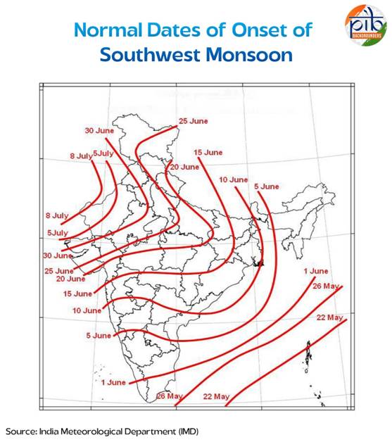
The season usually begins in early June when the monsoon winds reach Kerala. Over the next few weeks, these winds spread across the entire country. By the middle of July, most of India is covered. The process starts because land heats up faster than the sea during summer. This creates low pressure over northern and central India. At the same time, the Indian Ocean stays cooler, leading to higher pressure over the sea. Moist winds flow from the ocean to the land, bringing rain.
These winds are called southwesterlies because they blow from the southwest. They split into two branches. One travels along the Arabian Sea and brings rain to the western coast and central India. The other moves across the Bay of Bengal and reaches eastern and northeastern parts of the country. As these winds hit mountain ranges like the Western Ghats and the Himalayas, they rise, cool, and release rain. The monsoon weather systems forming over the warm Bay of Bengal bring plenty of rains when they move across northern parts of the country. This monsoon is especially important for crops like rice, cotton, and sugarcane. A delay or failure in this season can affect food supply, livelihoods, and the wider economy.
Northeast Monsoon (October to December)
As the southwest monsoon begins to fade, the northeast monsoon sets in by October. This is also called the retreating monsoon. It is shorter and less widespread but still important, especially for southern India.
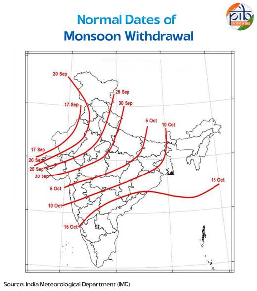
By October, the land starts to cool faster than the ocean. This creates a high-pressure area over the Indian subcontinent and a low-pressure area over the surrounding seas. The direction of wind flow reverses. Now, winds blow from land to sea. These are called northeasterlies.
Since these winds pass over the Bay of Bengal before reaching the southeastern coast, they pick up some moisture. As they reach Tamil Nadu, south Andhra Pradesh and parts of Sri Lanka, they provide abundant moisture for rainfall activity. This rain is crucial for regions like Tamil Nadu that do not receive much during the southwest monsoon. Weather systems forming over south Bay of Bengal bring abundant rainfall over south Peninsula.
Factors Affecting Indian Monsoon
The Indian monsoon is a complex weather system shaped by many natural forces. These forces decide when the rains arrive, how much rain falls, and how long the season lasts. While some factors work at a global scale, others are more local. Together, they guide the flow of winds, the rise of clouds, and the spread of rainfall across the country.
Some of the most notable factors that affect Indian monsoon include:
Inter-Tropical Convergence Zone (ITCZ)
The Inter-Tropical Convergence Zone, or ITCZ, plays a major role in shaping the Indian monsoon. It is a narrow belt near the Equator where winds from the northern and southern hemispheres meet. This zone is known for low pressure and rising warm air, which often leads to cloud formation and rain.
During the summer months, the ITCZ moves northward, following the Sun. In July, it can reach as far as the Gangetic plains in northern India. This movement is important because it pulls in moist winds from the oceans towards the land. These winds become part of the southwest monsoon.
As the ITCZ shifts north, it creates a zone of strong convection. That means warm air rises quickly, forms clouds, and brings rain. This low-pressure area is sometimes called the monsoon trough when it forms over land. It is especially active during the peak monsoon months and helps produce long spells of rain in many parts of the country.
The ITCZ also explains why the monsoon arrives in India in early June. When the Sun starts heating the Indian landmass, the ITCZ begins its northward journey. This change in its position helps draw in the trade winds from the southern hemisphere. After crossing the Equator, these winds bend due to the Earth’s rotation and arrive in India from the southwest. These are the southwest monsoon winds.
Later in the year, around October, the ITCZ starts moving south again. As it retreats, the winds reverse. Now they blow from the northeast, leading to the start of the northeast monsoon. This shows how closely the Indian monsoon is linked to the yearly movement of the ITCZ.
In short, the ITCZ acts like a switch that helps turn the monsoon on and off. Its position decides the direction of winds, the spread of rain, and the arrival and withdrawal of the monsoon across the country.
The basics of monsoon and its variability can be well explained in terms of ITCZ rather than the gigantic sea breeze theory.
El Niño is a natural climate event that forms in the Pacific Ocean but influences weather patterns across the world, including India. It happens when warm water builds up along the coast of South America, especially near Peru and eastern parts of the equatorial Pacific. This rise in ocean temperature changes the movement of air and clouds across the globe, which can disturb regular wind patterns. For India, this often results in a weak or delayed monsoon season.
During an El Niño year, the usual flow of moist winds towards India is disrupted. This change reduces the amount of rainfall India receives between June and September. In the past, strong El Niño events have led to serious drops in rainfall, late arrival of the monsoon, and dry spells in key agricultural states.
To reduce the risks, Indian weather agencies monitor ocean temperatures and pressure changes closely. The India Meteorological Department uses these signals to forecast long-term monsoon patterns and issue early warnings. This helps farmers, governments, and disaster relief agencies prepare in advance. Since 1950, there have been 16 El Niño years, out of which 7 years had impacted Indian monsoon rainfall when rainfall was below normal.
La Niña and the Indian Monsoon
La Niña is a natural climate pattern that causes the central and eastern parts of the Pacific Ocean to cool more than usual. This change in ocean temperature affects global weather, including India’s monsoon. During La Niña years, most regions in India receive normal to above-normal rainfall in the southwest monsoon season. This is especially helpful for rainfed farming and water storage. However, the excessive rain can sometimes lead to floods, damage to crops, and the loss of livestock in certain areas.
Unlike El Niño, which often weakens the Indian monsoon and leads to dry conditions, La Niña usually strengthens it. While El Niño is linked to warm ocean waters and weaker monsoon winds, La Niña is marked by cooler waters and stronger moisture-bearing winds towards India. In simple terms, El Niño tends to bring less rain and more uncertainty, while La Niña often brings heavier rainfall. Also, below-normal temperatures are generally observed during the winter season during the La Niña years.
Distribution of Rainfall in India
Rainfall in India is not the same everywhere. Some regions receive very heavy rain, while others remain mostly dry. The average annual rainfall in India is about 125 cm, but it has great spatial variations. This uneven pattern is linked to the path of the monsoon winds and the shape of the land. As monsoon winds vary from year to year, the rainfall is not always the same. This variation is called rainfall variability. Indian monsoon exhibits a wide spectrum of variability, on diurnal, synoptic, sub-seasonal, interannual, decadal and centennial time scales. The active-break cycles of monsoon rainfall represent the sub-seasonal variability of the Indian monsoon. A significant fraction of the interannual variations of monsoon rainfall is associated with tropical and subtropical ocean climate.
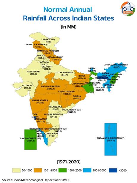
The western coast and parts of Northeast India get the highest rainfall. These areas receive more than 400 centimetres of rain every year. The winds from the Arabian Sea hit the Western Ghats, forcing the air to rise. As the air rises, it cools and forms clouds, leading to heavy rain. This is known as orographic rainfall and is common along mountain slopes. Similarly, the hills in the Northeast act like barriers and bring large amounts of rain to places like Meghalaya and Arunachal Pradesh.
In contrast, parts of western Rajasthan and nearby regions in Gujarat, Haryana and Punjab get very little rain. These areas receive less than 60 centimetres of rain annually. The Deccan plateau and areas east of the Sahyadri hills also get low rainfall. These places lie in the rain shadow region, meaning the hills block the rain-bearing winds. Leh, in Ladakh, is another area with very low rainfall due to its high altitude and cold desert climate. Most other parts of India receive moderate rainfall. Snowfall is limited to the Himalayan region.
Monsoons and the Economic Life in India
The monsoon is central to India’s economy, especially its agricultural sector. With a large part of the population relying on farming, the success or failure of the monsoon can shape the country’s overall economic health.
- Nearly 64 per cent of Indians depend on agriculture, which mainly relies on the southwest monsoon.
- Only about 55 per cent of India’s net sown area is covered by irrigation. The rest depends on rain-fed systems, which makes a large part of the country’s farmland highly vulnerable to changes in rainfall patterns.
- Good monsoon raises agricultural production, aids GDP growth, drives up rural earning and consumption.
- Most parts of the country stay warm enough for farming throughout the year, except the Himalayan region.
- Different rainfall patterns across regions allow a wide variety of crops to be grown.
- Uneven or late rainfall often causes floods or droughts, affecting both crops and rural incomes.
- Areas without proper irrigation suffer the most when the monsoon is weak or delayed.
- Sudden and intense rain can lead to soil erosion, harming the fertility of land.
- Winter rain in north India, brought by western disturbances, is helpful for wheat and other rabi crops.
- Local climate, shaped by the monsoon, also influences food habits, clothing styles and types of houses across India.
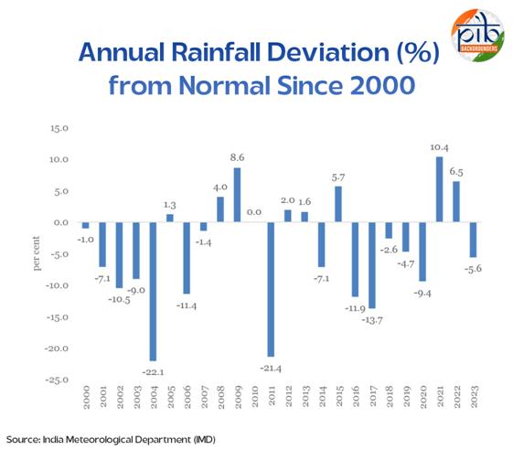
Monsoon Patterns Over the Years
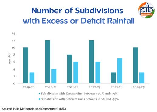
Southwest monsoon rainfall in India can vary greatly from year to year. One way to track these changes is by looking at how many regions, called meteorological sub-divisions, receive less than normal rain. These are classified as deficient when rainfall is 20 to 59 per cent below normal, and large deficient when it is 60 to 99 per cent below normal.
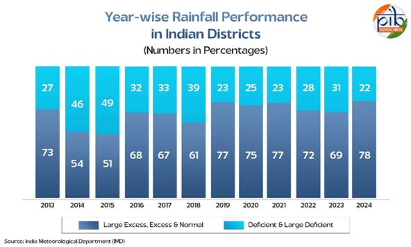
In 2015, as many as 16 sub-divisions recorded deficient or large deficient rainfall, the highest in the past decade. The numbers remained high in 2016 and 2018, with 10 and 11 sub-divisions affected respectively. However, 2019 saw a sharp improvement, with only 3 sub-divisions facing low rainfall.
The pattern stayed relatively steady from 2020 to 2023, with 5 to 7 sub-divisions receiving deficient rain. In 2024, the number again dropped to 3, suggesting a more balanced rainfall distribution in that year. These shifts highlight how the monsoon remains unpredictable and why accurate forecasting is vital for planning and preparedness.
District-wise rainfall performance has improved noticeably over the years. In 2024, 78 per cent of districts recorded normal, excess or large excess rainfall, showing the best performance in more than a decade. This is a sharp contrast to 2015, when only 51 per cent of districts received sufficient rain.
India received a good amount of rainfall during the southwest monsoon season in 2024. From June to September, the country recorded 934.8 mm of rainfall, which is 108 per cent of the Long Period Average (LPA) of 868.6 mm (based on the 1971–2020 average). This indicates that the monsoon was both timely and strong in most parts of the country.
| Long Period Average (LPA)The Long Period Average, or LPA, is the average rainfall a region receives over a long stretch of time, usually 30 years. It is used as a reference point to understand how much rain is normal for a place during a month or a season. |
|
Rainfall by Region (% of LPA)
|
|
Region
|
Rainfall (% of LPA)
|
|
East & Northeast India
|
86%
|
|
Northwest India
|
107%
|
|
Central India
|
119%
|
|
South Peninsula
|
114%
|
Central and southern India received much higher-than-average rainfall, while East and Northeast India experienced a shortfall.
|
Rainfall by Month (% of LPA)
|
|
Month
|
Rainfall (% of LPA)
|
|
June
|
89%
|
|
July
|
109%
|
|
August
|
115%
|
|
September
|
112%
|
After a slightly below-normal start in June, the monsoon strengthened significantly in the following months, with August recording the highest rainfall.
Climate Change and the Indian Monsoon
Climate change is beginning to reshape the behaviour of the Indian monsoon. According to Dr Rajeevan Madhavan Nair, former Secretary of the Ministry of Earth Sciences, while the total rainfall across the country has not shown a clear long-term trend on a national average, there are large spatial variations. Some regions, like Kerala, parts of Northeast India and East Central India, are receiving less rainfall over the monsoon season. In contrast, areas such as North Karnataka, Maharashtra and Rajasthan have seen an increase in rainfall. He has also noted that the frequency of extreme rainfall events, especially those over 150 mm in a day, are becoming more common, rising by about two events every decade.
In fact, experts have noted that in central India, the frequency of extreme daily rainfall events crossing 150 mm has increased by around 75 per cent between 1950 and 2015.
There has also been a noticeable increase in the number of dry spells during the summer monsoon season. These dry periods have become 27 per cent more common between 1981 and 2011 compared to the earlier period from 1951 to 1980. Alongside this, the number of years with deficient rainfall at the all-India level has increased. More meteorological subdivisions are also experiencing rainfall shortfalls, pointing to both a higher frequency and wider geographic spread of droughts.
The changing nature of the monsoon has serious consequences for agriculture. While long dry spells are becoming more frequent, short wet spells are becoming more intense. Dr Nair has also noted that nearly half of the season’s rainfall now falls within just 20 to 30 hours, covering only about 20 per cent of the monsoon period. The remaining 50 per cent of rainfall occurs as light to moderate rain over 80 per cent of the time. This uneven distribution affects water availability, soil health and crop productivity.
Further, shifts have been observed in monsoon timing and distribution. July, once a peak month for rain, is now showing a decline in rainfall, while September is becoming wetter. The onset and withdrawal of the monsoon have also shifted in different parts of the country. Added to this, more frequent El Niño and La Niña events are contributing to the variability in rainfall. Together, these changes are making the Indian monsoon less predictable and more challenging to manage for farmers, planners and water managers.
Role of the India Meteorological Department (IMD)
The India Meteorological Department (IMD), under the Ministry of Earth Sciences, plays a key role in delivering critical weather and climate services across the country. Established in 1875, IMD supports a wide range of sectors including disaster management, agriculture, aviation, and public safety, by providing reliable forecasts and early warnings.
IMD plays a central role in tracking, studying and forecasting the Indian monsoon. It is the main government agency responsible for providing long-range weather forecasts and issuing early warnings related to rainfall.
| ForecastingForecasting in science means estimating the value of something that will happen in the future. In weather science, it involves predicting conditions like rainfall, temperature, wind and humidity over a given area and time. |
Seasonal Forecasts (Or long-range forecasts) for the southwest monsoon are released in two stages. The first forecast comes out in mid-April and gives an overall estimate of how much rain the country is expected to receive during the season. The second forecast is issued at the end of June. This provides an update to the earlier prediction, along with more specific information such as expected rainfall in July and likely rainfall patterns across different regions. By middle of May, IMD also predicts the onset date of southwest monsoon.
Apart from the southwest monsoon, IMD also prepares rainfall forecasts for the northeast monsoon, which affects southern India between October and December. It also issues predictions for winter rainfall in northwestern India, especially during January to March. However, these forecasts are meant for internal government use and are not released to the general public.
Over the last four years, from 2021 to 2024, the India Meteorological Department (IMD) has maintained 100 per cent accuracy in forecasting the all-India southwest monsoon rainfall. Each year's forecast fell within the model's accepted margin of error (±5 per cent of the long period average), showing the growing reliability of India's weather prediction systems.
These accurate forecasts have helped in better planning for agriculture, water management, and disaster preparedness across the country.
|
All-India Southwest Monsoon Forecast vs Actual Rainfall
|
|
Year
|
Forecast (% of LPA)
|
Actual (% of LPA)
|
Accuracy Status
|
|
2021
|
101
|
100
|
Accurate
|
|
2022
|
103
|
106
|
Accurate
|
|
2023
|
96
|
95
|
Accurate
|
|
2024
|
106
|
108
|
Accurate
|
Note: Forecast considered accurate if within ±5% of the Long Period Average (LPA).
Other Notable Achievements:
The India Meteorological Department (IMD) has made significant progress in weather forecasting and monitoring over the past decade. Some of the notable achievements of the IMD include:
1. Improved Forecast Accuracy
- Forecast accuracy improved by 40 per cent in 2023 compared to 2014.
- This progress has enhanced early warning systems and disaster preparedness across the country.
2. Cyclone Forecasting Success
- IMD successfully predicted major cyclones such as Phailin (2013), Hudhud (2014), Fani (2019), Amphan (2020), Tauktae (2021), Biparjoy (2023), and Dana (2024).
- Thanks to timely and accurate cyclone warnings, the number of cyclone-related deaths dropped from 10,000 in 1999 to zero between 2020 and 2024.
3. Expansion of Radar Network
- The Doppler Weather Radar network expanded from 15 in 2014 to 39 in 2023.
- This increased land coverage by about 35 per cent and strengthened real-time monitoring capabilities.
4. Technological Innovations
- Introduction of the High-Resolution Rapid Refresh (HRRR) model for nowcasting of rainfall and reflectivity.
- Launch of the Electric Weather Research and Forecasting (EWRF) model for lightning and rainfall forecasts.
- Release of Mausamgram on 15 January 2024, a user-friendly platform offering local weather updates, launched by the Vice President of India during IMD’s 150th foundation day.
5. Strengthened Ground Observation
- Increase in the number of Automatic Rain Gauges (ARGs) from 1,350 in 2014 to 1,382 in 2023.
- District-wise Rainfall Monitoring Scheme (DRMS) stations rose from 3,955 in 2014 to 5,896 in 2023.
Mission Mausam
Mission Mausam is a new Central Sector Scheme approved by the Cabinet on 11 September 2024. Its aim is to reduce the impact of extreme weather events caused by climate change and build stronger, more resilient communities. The broader goal is to make Bharat a "weather-ready and climate-smart" nation.
The mission focuses on improving how India monitors and predicts weather. This will be done by using advanced tools such as high-resolution weather radars, satellites with better instruments, and next-generation computing systems. It also plans to use artificial intelligence and machine learning to improve forecasting.
To carry out its vision, Mission Mausam has been organised into nine verticals, each led by institutes under the Ministry of Earth Sciences. These verticals will work together to improve real-time weather and climate services across the country and nearby regions.
Nine Verticals of Mission Mausam:
- OBSERVE_All: Collects and monitors weather data for forecasting and decision-making.
- DEVELOP: Works on building next-generation Earth System Models for better predictions.
- IMPACT: Focuses on early warnings for severe weather events and turning research into practice.
- FRONTIER: Builds new technologies for observing and measuring weather.
- ATCOMP: Develops tools for air quality tracking and pollution management.
- DECIDE: Designs decision-support systems for sectors like agriculture, water, and energy.
- Weather_MOD: Prepares strategies for weather modification like rain enhancement or fog control.
- LEAD: Builds capacity and improves the way weather updates are shared with people.
- NEAT: Encourages partnerships with private firms for improved observation systems.
Many parts of Mission Mausam build upon and improve the existing ACROSS sub-scheme under the PRITHVI programme. As a result, ACROSS will now be merged with this new mission. Mission Mausam will be implemented in two phases: from 2024 to 2026, and continued from 2026 to 2031 in the next funding cycle.
Lightning Strikes in India
Lightning is one of the most powerful and dangerous natural phenomena. A single lightning strike can carry between 100 million and 1 billion volts of electricity. It also releases billions of watts of power and produces extreme heat, reaching over 35,000 degrees Fahrenheit. This is hotter than the surface of the Sun. The heat is strong enough to melt metal and even turn sand into glass. Lightning strikes remain a serious weather-related hazard in India, especially during the monsoon months.
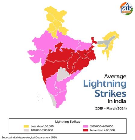
States like Gujarat, Rajasthan and Punjab registered an increase in lightning strikes, indicating a new and emerging trend. Earlier, Northeast India was considered the hotspot for lightning, but recent data from both IITM and the National Remote Sensing Centre (NRSC) show that eastern and central India are now witnessing more frequent lightning events.
Conclusion
The monsoon is not just a weather pattern; it is the heartbeat of India’s economy, environment and everyday life. From sowing seeds in rural fields to powering cities through hydroelectricity, its influence is vast and far-reaching. While the science behind the monsoon has grown more precise over the years, its unpredictable nature still reminds us of the delicate balance between nature and human activity.
Accurate forecasting, early warning systems and scientific missions like Mission Mausam are helping the country prepare better for the changes each season may bring. At the same time, rising challenges such as climate change and extreme weather events require continued investment in research, technology and public awareness.
Understanding the monsoon is not just about studying rain and winds. It is about recognising how closely weather is tied to the lives and futures of millions. As India continues to develop, staying weather-ready and climate-smart will be key to building a safer, more resilient nation.
References:
NCERT:
IMD:
PIB Backgrounder:
Ministry of Earth Sciences:
Economic Survey 2024-25
Download in PDF
***
SK/SM
(Explainer ID: 154892)
आगंतुक पटल : 41460
Provide suggestions / comments