|
Ministry of Earth Sciences
IMD Forecasts Enhanced Rainfall Across East, Northeast India and Western Himalayan Region Over Next 7 Days; Extremely Heavy Rain Alert Issued for Odisha Today
Well-Marked Low-Pressure Area Over Bay of Bengal to Bring Heavy to Extremely Heavy Rainfall in Odisha and Eastern India; Subdued Activity in South Peninsula IMD Issues Orange and Red Warnings for Heavy Rainfall in Odisha and Central-East India; Advises Fishermen and Farmers to Follow Safety Protocol
Posted On:
16 JUL 2026 2:42PM by PIB Delhi
Subject: (i) Under the influence of Well-marked low-pressure area over northwest Bay of Bengal and adjoining north Odisha -West Bengal coasts, enhanced rainfall activity with isolated heavy to very heavy falls over East & Northeast India, East Uttar Pradesh and Western Himalayan Region during next 7 days. Isolated extremely heavy rainfall also likely over Odisha on today, 16th July, 2026.
(ii) Subdued rainfall activity likely to continue over westcentral & south Peninsular India during next 7 days and over plains of northwest India during next 3 days.
Realised weather during past 24 hours ending at 0830 hours IST of today, the 16th July, 2026:
- Extremely heavy rainfall (≥21 cm) has been recorded over Odisha.
- Very Heavy rainfall (12-20 cm) has been recorded over Arunachal Pradesh, Assam and Bihar.
- Heavy rainfall (7-11 cm) has been recorded over East Madhya Pradesh, Chhattisgarh, Konkan, Sub-Himalayan West Bengal, Nagaland and Tripura.
- Thunderstorm accompanied with Squally/Gusty winds with speed reaching 60-80 kmph at isolated places over Punjab and Gujarat Region; with speed reaching 40-60 kmph at isolated places over Andaman & Nicobar Islands, Odisha, Bihar, Jharkhand, Haryana, Rajasthan, Madhya Pradesh, Vidarbha, Madhya Maharashtra, Marathawada, Saurashtra & Kutch.
Weather Systems, Forecast and Warnings (Annexure I & II):
-
- The low pressure over Northwest Bay of Bengal and adjoining North Odisha -West Bengal coasts lay as a Well-marked low-pressure area over the same region at 0830 hrs IST of today, 16th July, 2026. It is very likely to move northwestwards across North Odisha & Gangetic West Bengal during next 2 days.
- The western end of the Monsoon trough at mean sea level is north its normal position and its eastern end is near its normal position.
- The Western Disturbance as a cyclonic circulation lies over Jammu division & neighbourhood in middle tropospheric levels with the trough aloft roughly along Long. 75°E to the north of Lat. 30°N.
- An upper air cyclonic circulation lies over north Haryana & neighbourhood in lower tropospheric levels.
- An upper air cyclonic circulation lies over East Uttar Pradesh & adjoining Bihar in lower tropospheric levels.
- An upper air cyclonic circulation lies over southwest Rajasthan & neighbourhood in lower tropospheric levels.
-
- A trough runs from the cyclonic circulation associated the Well marked low pressure area over Northwest Bay of Bengal and adjoining North Odisha -West Bengal coasts to Eastcentral Arabian Sea in middle tropospheric levels.
- A fresh Western Disturbance is likely to affect Northwest India from 19th July, 2026.
Under the influence of above systems, the following weather is likely:
Northwest India:
-
- Isolated to Scattered rainfall likely over Himachal Pradesh and Jammu-Kashmir-Ladakh-Gilgit-Baltistan-Muzaffarabad during 16th-17th July.
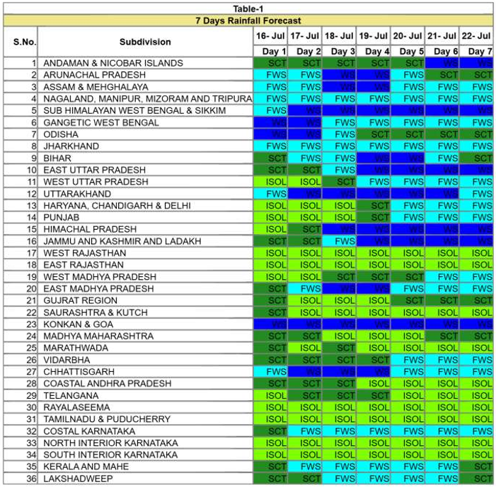
- Isolated to Scattered rainfall likely over Haryana Chandigarh & Delhi and Punjab during 16th-19th July; West Uttar Pradesh during 16th-18th July; East Uttar Pradesh during 16th-17th July; East Rajasthan and West Rajasthan during 16th-22nd July.
- Fairly Widespread to Widespread rainfall likely over Himachal Pradesh and Jammu-Kashmir-Ladakh-Gilgit-Baltistan-Muzaffarabad during 18th-22nd July; Uttarakhand during 16th-22nd July.
- Fairly Widespread to Widespread rainfall likely over Haryana Chandigarh & Delhi and Punjab during 20th-22nd July; West Uttar Pradesh during 19th-22nd July; East Uttar Pradesh during 18th-22nd July.
- Isolated thunderstorm, lightning & gusty winds (speed reaching 40-50 kmph gusting to 60 kmph) likely over Jammu-Kashmir-Ladakh-Gilgit-Baltistan-Muzaffarabad during 16th-22nd July.
- Isolated thunderstorm, lightning & gusty winds (speed reaching 30-40 kmph gusting to 50 kmph) likely over East Rajasthan and West Rajasthan during 20th-22nd July.
- Isolated thunderstorm & lightning likely over Himachal Pradesh on 17th July; East Uttar Pradesh and Uttarakhand during 16th-22nd July.
- Isolated heavy rainfall likely over Jammu-Kashmir-Ladakh-Gilgit-Baltistan-Muzaffarabad during 19th-20th July and on 22nd July; Himachal Pradesh on 18th July; Uttarakhand during 16th-17th July and on 22nd July; Haryana Chandigarh & Delhi and Punjab during 20th-22nd July; West Uttar Pradesh during 19th-22nd July; East Uttar Pradesh during 17th-18th July and on 22nd July with isolated very heavy rainfall also likely over Jammu-Kashmir-Ladakh-Gilgit-Baltistan-Muzaffarabad on 21st July; Himachal Pradesh during 19th-22nd July; Uttarakhand during 18th-21st July; East Uttar Pradesh during 19th-21st July.
Central India:
-
- Isolated to Scattered rainfall likely over West Madhya Pradesh during 16th-20th July; East Madhya Pradesh on 16th July; Vidarbha during 16th-19th July.
- Fairly Widespread to Widespread rainfall likely over West Madhya Pradesh during 21st-22nd July; East Madhya Pradesh during 17th-22nd July; Vidarbha during 20th-22nd July; Chhattisgarh during 16th-22nd July.
- Isolated thunderstorm, lightning & gusty winds (speed reaching 40-50 kmph gusting to 60 kmph) likely over East Madhya Pradesh, Vidarbha and West Madhya Pradesh during 16th-20th July.
- Isolated thunderstorm & lightning likely over Chhattisgarh during 16th-20th July.
- Isolated heavy rainfall likely over Chhattisgarh and East Madhya Pradesh during 17th-21st July; Vidarbha during 17th-18th July with isolated very heavy rainfall also likely over Chhattisgarh on 16th July.
East India:
-
- Isolated to Scattered rainfall likely over Andaman & Nicobar Islands during 16th-20th July; Bihar on 16th July and on 22nd July; Odisha during 19th-22nd July.
- Fairly Widespread to Widespread rainfall likely over Andaman & Nicobar Islands during 21st-22nd July; Gangetic West Bengal, Jharkhand and Sub-Himalayan West Bengal & Sikkim during 16th-22nd July; Bihar during 17th-21st July; Odisha during 16th-18th July.
- Isolated thunderstorm, lightning & gusty winds (speed reaching 40-50 kmph gusting to 60 kmph) likely over Andaman & Nicobar Islands on 16th July; Gangetic West Bengal during 16th-17th July; Jharkhand during 16th-20th July, with gusty winds (speed reaching 30-40 kmph gusting to 50 kmph) likely over Andaman & Nicobar Islands during 17th-22nd July; Gangetic West Bengal during 18th-20th July; Bihar during 16th-22nd July.
- Isolated thunderstorm & lightning likely over Sub-Himalayan West Bengal & Sikkim during 16th-22nd July.
- Isolated heavy rainfall likely over Bihar and Sub-Himalayan West Bengal & Sikkim during 16th-17th July and during 21st-22nd July; Gangetic West Bengal during 16th-17th July; Jharkhand during 16th-18th July; Odisha on 16th July and during 18th-20th July with isolated very heavy rainfall also likely over Bihar and Sub-Himalayan West Bengal & Sikkim during 18th-20th July; Odisha on 17th July.
- Heavy to very heavy rainfall at few places with extremely heavy rainfall likely at isolated places over Odisha on 16th July.
Northeast India:
-
- Fairly Widespread to Widespread rainfall likely over Arunachal Pradesh during 16th-20th July; Assam & Meghalaya and Nagaland, Manipur, Mizoram & Tripura during 16th-22nd July.
- Isolated to Scattered rainfall likely over Arunachal Pradesh during 21st-22nd July.
- Isolated thunderstorm & lightning likely over Arunachal Pradesh during 16th-18th July; Assam & Meghalaya and Nagaland, Manipur, Mizoram & Tripura during 16th-20th July.
- Isolated heavy rainfall likely over Arunachal Pradesh on 16th July and during 20th-22nd July; Assam & Meghalaya during 20th-22nd July; Nagaland, Manipur, Mizoram & Tripura during 16th-22nd July with isolated very heavy rainfall also likely over Arunachal Pradesh during 17th-19th July; Assam & Meghalaya during 16th-19th July.
West India:
-
- Fairly Widespread to Widespread rainfall likely over Konkan & Goa during 16th-22nd July.
- Isolated to Scattered rainfall likely over Gujarat Region, Madhya Maharashtra, Marathawada and Saurashtra & Kutch during 16th-22nd July.
- Isolated thunderstorm, lightning & gusty winds (speed reaching 40-50 kmph gusting to 60 kmph) likely over Konkan & Goa on 16th July; Madhya Maharashtra during 16th-17th July; Marathawada during 16th-18th July.
- Isolated heavy rainfall likely over Konkan & Goa and Madhya Maharashtra on 16th July.
South Peninsular India:
-
- Isolated to Scattered rainfall likely over Coastal Andhra Pradesh & Yanam, North Interior Karnataka, Rayalaseema, South Interior Karnataka, Tamil Nadu, Puducherry & Karaikal and Telangana during 16th-22nd July; Kerala & Mahe on 16th July and on 22nd July; Lakshadweep during 16th-17th July and on 22nd July; Coastal Karnataka on 16th July.
- Fairly Widespread to Widespread rainfall likely over Kerala & Mahe during 17th-21st July; Lakshadweep during 18th-21st July; Coastal Karnataka during 17th-22nd July.
- Isolated thunderstorm, lightning & gusty winds (speed reaching 40-50 kmph gusting to 60 kmph) likely over Coastal Andhra Pradesh & Yanam on 16th July; Rayalaseema during 16th-17th July; Telangana during 16th-18th July, with gusty winds (speed reaching 30-40 kmph gusting to 50 kmph) likely over Tamil Nadu, Puducherry & Karaikal during 17th-20th July; Coastal Karnataka, North Interior Karnataka and South Interior Karnataka on 19th July; Rayalaseema during 18th-20th July; Telangana during 19th-20th July.
-
- Isolated thunderstorm & lightning likely over Kerala & Mahe during 16th-17th July; North Interior Karnataka during 17th-18th July; Coastal Andhra Pradesh & Yanam on 17th July.
- Isolated heavy rainfall likely over Coastal Andhra Pradesh & Yanam on 16th July.
- Strong Surface Winds likely over Coastal Karnataka, North Interior Karnataka and South Interior Karnataka on 19th July; Rayalaseema and Telangana during 16th-20th July.
Heat Wave and Hot & Humid weather conditions warning:
-
- Heat wave conditions very likely in isolated pockets over Coastal Andhra Pradesh & Yanam and Rayalaseema on 16th July; Tamil Nadu, Puducherry & Karaikal during 16th-17th July.
- Hot and humid weather conditions likely to prevail over Haryana Chandigarh & Delhi and Punjab during 16th-18th July; East Uttar Pradesh, Telangana and West Uttar Pradesh on 16th July; Tamil Nadu, Puducherry & Karaikal during 16th-17th July; Coastal Andhra Pradesh & Yanam and Rayalaseema on 17th July.
Fishermen Warning:
Fishermen are advised not to venture:
Arabian Sea: Along and off Somalia, Oman, over most parts of west central adjoining some parts of south west Arabian Sea during 16th to 21st July & few parts of northwest Arabian Sea during 16th to 18th July; along and off Gujarat Coast during 18th to 21st July and North Maharashtra Coast during 19th to 20th July.
Bay of Bengal: Along and off Gangetic West Bengal and Odisha coast adjoining most parts of north and few parts of central Bay of Bengal, some parts of south Bay of Bengal and adjoining areas during 16th to 18th July, over Andaman Sea during 16th to 17th July.
Weather conditions and forecast over Delhi/NCR during next 4 days (Annexure III) For more details, kindly refer National Weather Bulletin: https://mausam.imd.gov.in/responsive/all_india_forcast_bulletin.php
For District wise warnings refer: https://mausam.imd.gov.in/responsive/districtWiseWarningGIS.php For Fishermen warning refer https://rsmcnewdelhi.imd.gov.in/fishermenwarning.php
Significant rainfall recorded (in cm) (from 0830 hours IST of yesterday to 0830 hours IST of today):
- Odisha: Banki 21;
- Assam & Meghalaya: Margherita (dist Tinsukia) 16, Matijuri (dist Hailakandi) 16, Matijuri Arg (dist Hailakandi) 13, Cacher Kvk Aws (dist Cachar) 9, Lakhipur Arg (dist Cachar) 8, Chauldhowaghat (dist Lakhimpur) 8, Chouldhuwaghat Arg (dist Lakhimpur) 8, A P Ghat (dist Cachar) 8, Udaipur (dist Tinsukia) 8, Mawkyrwat (dist South West Khasi Hills) 7, Kokrajhar (dist Kokrajhar) 7, N.lakhimpur/lilabari (dist Lakhimpur) 7, Moranhat (dist Dibrugarh) 7;
- Bihar: Mainatand (dist West Champaran) 15, Sikta (dist West Champaran) 13, Khizirsarai (dist Gaya) 5;
- Arunachal Pradesh: Itanagar (dist Papumpara) 13, Naharlagun_ Aws (dist Papumpara) 7;
- Chhattisgarh: Shankargarh (dist Balrampur) 9, Kusmi (dist Balrampur) 9, Chando (dist Balrampur) 8, Patna (dist Koriya) 6;
- Tripura & Nagaland: Kadamtala Arg (dist North Tripura) 11, Jharnapani _aws (dist Dimapur) 7;
- East Madhya Pradesh: Ramnagar (dist Maihar) 9, Deori (dist Sagar) 5;
- Konkan: Jawhar (dist Palghar) 9, Mokheda - Fmo (dist Palghar) 6;
- Sub-Himalayan West Bengal: Buxaduar (dist Alipurduar) 8, Beech Tea Garden (dist Alipurduar) 7, Yuksom (dist Gyalshing)
Gusty winds (in >=40 kmph) (from 0830 hours IST of yesterday to 0830 hours IST of today):
- Gujarat Region: Arnej 65;
- Punjab: Muktsar - 63; Faridkot - 48; Firozpur - 46; Bhatinda - 46; Fazilka - 39
- Andaman & Nicobar Islands: Sri Vijayapuram - 60
- Madhya Maharashtra: Kalwan (Nashik) - 57; Shahada (Nandurbar) - 54
- Saurashtra & Kutch: Rajkot 56
- Haryana: Sirsa - 54; Hisar - 46
- Marathwada: Chakur (Latur) - 52; Vaijnath (Beed) - 50
- West Uttar Pradesh: Muzaffarnagar (AWS) - 50; Agra (AWS) - 39; Jhansi (AWS) - 39; Lalitpur (AWS) - 39
- Bihar: Bikramganj - 48
- East Rajasthan: Ajmer - 48
- Jharkhand: Ranchi - 46
- East Madhya Pradesh: Jabalpur 46, Rewa 41
- Vidarbha: Akola - 43; Yavatmal - 39; Wardha - 37; Nagpur - 33; Buldana - 33; Chandrapur - 30
- East Uttar Pradesh: Lucknow (AWS Integral University) - 42; Banda (AWS) - 39
- Odisha: Mayurbhanj - 41
- West Rajasthan: Bikaner - 41; Sri Ganganagar - 37
- West Madhya Pradesh: Datia 41.
Annexure I
-
- As the lead period increases forecast accuracy decrease.
Annexure II
-
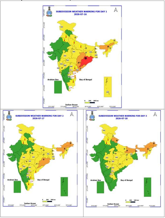
- Action may be taken based on ORANGE AND REDCOLOUR warnings.
- Vulnerable regions likely urban and hilly areas action may be initiated for heavy rainfall warning.
- As the lead period increases forecast accuracy decreases.
Detailed district-wise Multi-Hazard weather warning for next five days available at https://mausam.imd.gov.in/responsive/districtWiseWarningGIS.php
Annexure III
Weather forecast over Delhi/NCR during 16th July to 19th July 2026 Past Weather:
There has been no large change in maximum and rise in minimum temperature by 1-3°C over Delhi during past 24 hours. The maximum temperatures were in the range of 37-38°C and the minimum temperatures are in the range 27-30°C respectively during past 24 hours over Delhi. The minimum temperatures are appreciably above normal (3.1°C to 5.0°C) at isolated places, above normal (1.6°C to 3.0°C) at a few places and normal (-1.5 to 1.5°C) over the remaining parts of Delhi. The maximum temperatures were appreciably above normal (3.1°C to 5.0°C) at a few places and above normal (1.6°C to 3.0°C) over the remaining parts of Delhi. Partly cloudy sky with surface wind speed 20 kmph gusting to 33 kmph from the southwest direction prevailed over Delhi during past 24 hours. Partly cloudy sky with surface wind speeds up to 25 kmph likely to prevailed from the southwest direction over the region in the forenoon today.
Weather Forecast:
16.07.2026: Partly cloudy sky. Hot and humid conditions at isolated places. Strong surface wind speed reaching 20-30 kmph during the day. The maximum temperatures over Delhi are likely to be in the range of 37-39°C. The maximum temperatures will be above normal (1.6°C to 3.0°C) at many places with appreciably above normal (3.1°C to 5.0°C) at isolated places over Delhi. The predominant surface wind is likely to be from the west direction with surface wind speed reaching up to 20 kmph during the afternoon hours. The wind speed will decrease becoming up to 18 kmph from the west direction during evening and night.
17.07.2026: Partly cloudy sky. Hot and humid conditions at isolated places. Strong surface wind speed reaching 20-30 kmph during the day. Possibility of thunder development towards afternoon/evening. The maximum and minimum temperatures over Delhi are likely to be in the range of 38°C to 40°C and 28°C to 30°C, respectively. The minimum temperature will be above normal (1.6°C to 3.0°C) at most places, and the maximum temperatures will be above normal (1.6°C to 3.0°C) at many places with appreciably above normal (3.1°C to 5.0°C) at a few places over Delhi. The predominant surface wind is likely to be from southwest direction with surface wind speed reaching up to 25 kmph during the morning hours. The wind speed will decrease becoming up to 20 kmph from the west direction during the afternoon. The wind speed will decrease becoming up to 18 kmph from the west direction during evening and night. 18.07.2026: Generally cloudy sky. Hot and humid conditions at isolated places. A spell of very light to light rain at isolated places accompanied with strong surface winds speed reaching 20-30 gusting to 40 kmph towards forenoon/ afternoon. The maximum and minimum temperatures over Delhi are likely to be in the range of 35°C to 37°C and 28°C to 30°C, respectively. The minimum temperature will be near normal (-1.5°C to 1.5°C) at isolated places with above normal (1.6°C to 3.0°C) at many places, and the maximum temperatures will be near normal (-1.5°C to 1.5°C) at many places with above normal (1.6°C to 3.0°C) at isolated places over Delhi. The predominant surface wind is likely to be from southwest direction with surface wind speed reaching up to 25 kmph during the morning hours. The wind speed will decrease becoming up to 15 kmph from the west direction during the afternoon. The wind speed will increase becoming up to 20 kmph from the west direction during evening and night.
19.07.2026: Generally cloudy sky. A spell of very light to light rain accompanied with strong surface winds speed reaching 20-30 gusting to 40 kmph towards forenoon/ afternoon. The maximum and minimum temperatures over Delhi are likely to be in the range of 34°C to 36°C and 26°C to 28°C, respectively. The minimum temperature will be near normal (-1.5°C to 1.5°C) at most places, and the maximum temperatures will be near normal (-1.5°C to 1.5°C) at most places over Delhi. The predominant surface wind is likely to be from the west direction with wind reaching up to 20 kmph during the morning hours. The surface wind speed will decrease becoming up to 15 kmph from the southwest direction during the afternoon. The wind speed will decrease becoming up to 12 kmph from the west direction during evening and night.
Impact Expected & Action Suggested due to heavy/very heavy/extremely heavy rainfall
- Heavy to very heavy rainfall at few places with extremely heavy rainfall likely at isolated places over Odisha on 16th July.
Impact Expected
-
- Localized Flooding of roads, water logging in low lying areas and closure of underpasses mainly in urban areas.
- Occasional reduction in visibility due to heavy rainfall.
- Disruption of traffic in major cities due to water logging in roads leading to increased travel time.
- Minor damage to kutcha roads.
- Possibilities of damage to vulnerable structure.
- Localized Landslides/Mudslides/landslips/mudslips/landsinks/mudsinks.
- Damage to horticulture and standing crops in some areas due to inundation.
- It may lead to riverine flooding in some river catchments (for riverine flooding please visit Web page of CWC)
Action Suggested
-
- Check for traffic congestion on your route before leaving for your destination.
- Follow any traffic advisories that are issued in this regard.
- Avoid going to areas that face the water logging problems often.
- Avoid staying in vulnerable structure.
Impact expected and action suggested due to Heat wave conditions:
- Heat wave conditions very likely in isolated pockets over Coastal Andhra Pradesh & Yanam and Rayalaseema on 16th July; Tamil Nadu, Puducherry & Karaikal during 16th-17th July.
Alert Areas
-
- High temperature & increased likelihood of heat illness symptoms in people who are either exposed to sun for a prolonged period or doing heavy work.
- High health concern for vulnerable people e.g. infants, elderly, people with chronic diseases.
- Avoid heat exposure– keep cool. Avoid dehydration.
- Drink sufficient water- even if not thirsty.
- Use ORS, homemade drinks like lassi, torani (rice water), lemon water, buttermilk, etc. to keep yourself hydrated.
Agromet advisories for likely impact of Heavy Rainfall
- In Odisha, maintain continuous drainage and keep field channels clear to prevent prolonged waterlogging in rice, maize, pulses, oilseed and vegetable fields. Strengthen field bunds and postpone irrigation, fertilizer and plant protection operations until field conditions become suitable.
- In Assam, maintain continuous and effective drainage of excess rainwater from sugarcane, soybean, pigeon pea, jute, sesame fields and fruit orchards to prevent prolonged waterlogging. Harvest mature crops wherever field conditions permit.
- In Meghalaya, maintain effective drainage in rice nursery beds and fields of maize, cowpea, okra and ginger. Strengthen nursery bunds and field channels to prevent runoff, seedling washout and waterlogging.
- In Chhattisgarh, maintain continuous drainage in rice nurseries and standing fields of maize, soybean, pigeon pea and minor millets to prevent prolonged waterlogging. Postpone irrigation, fertilizer and plant protection operations until field conditions improve.
- In Arunachal Pradesh, ensure continuous drainage of excess rainwater from rice, maize, soybean and finger millet fields to prevent prolonged waterlogging.
- In Nagaland, Manipur, Mizoram and Tripura ensure continuous and effective drainage and remove any accumulated rainwater from soybean, black gram, ginger, turmeric, cole crop and vegetable fields to prevent residual waterlogging.
- In Sikkim, ensure proper drainage in rice nurseries and standing crop fields to prevent waterlogging.
- In West Bengal, ensure continuous and effective drainage in rice nurseries, jute, ginger and vegetable fields to prevent prolonged waterlogging. Inspect and strengthen bunds around rice nurseries and harvest mature tea leaves and vegetables wherever field conditions permit.
- In Jharkhand, ensure proper drainage in standing crop fields to prevent waterlogging. Postpone irrigation, fertilizer and plant protection operations until field conditions improve.
- In Bihar, ensure continuous drainage in rice, maize, sesame and pigeon pea fields to prevent prolonged waterlogging. Postpone irrigation, fertilizer and plant protection operations until field conditions improve.
- In Uttarakhand, postpone sowing of groundnut, soybean and maize. Ensure proper drainage in rice, tomato and chilli fields to prevent waterlogging. Harvest mature tomato only during rain-free periods and continue rice transplanting wherever field conditions permit.
- In Himachal Pradesh, ensure proper drainage in maize, finger millet, cucurbit, tomato and capsicum fields to prevent waterlogging. Harvest mature crops wherever field conditions permit.
- In West Uttar Pradesh, ensure proper drainage in rice, maize, sesame and pigeon pea fields to prevent waterlogging. Postpone irrigation, fertilizer and plant protection operations until field conditions improve.
Agromet advisories for likely impact of High temperatures/ Heat Waves
- In Tamil Nadu, Coastal Andhra Pradesh and Rayalaseema, maintain adequate soil moisture in standing crops through light and need-based irrigation to reduce the adverse effects of heat wave and hot & humid conditions.
Agromet advisories for likely impact of Thunderstorm / Gusty Winds
- In Arunachal Pradesh, Assam, Meghalaya, Nagaland, Manipur, Mizoram, Sikkim, West Bengal, West Madhya Pradesh, East Madhya Pradesh, Vidarbha, Chhattisgarh, Tamil Nadu, Keralam and Coastal Andhra Pradesh post-pone fertilizer application and other field activities.
- In Telengana and Rayalaseema and Coastal Andhra Pradesh provide staking or support to vegetables and young fruit plants / fruit-bearing plants to avoid lodging due to strong winds.
- Shift the harvested produce in safer places or cover the produce with tarpaulin sheets in the fields. Tie the harvested crops securely and cover them to minimize the risk of displacement from strong surface winds.
Livestock / Poultry / Fisheries
- Keep the animals inside the shed during heavy rainfall and provide them balanced feed.
- Store the feed and fodder in a safe place to prevent spoilage.
- In regions with high temperatures and heat wave conditions, provide clean, cool drinking water to animals, and cover the roofs of poultry sheds with grass to reduce the adverse effects of heat.
- Construct an outlet with proper netting around the ponds to drain excess water, thereby preventing fish from escaping in the event of overflow.
Flash Flood Guidance:
|
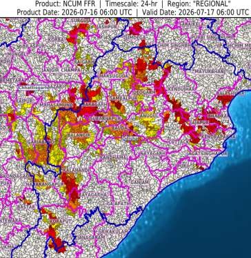
24 hours Outlook for the Flash Flood Risk (FFR) till 1130 IST of 17-07-2026 :
Low to Moderate flash flood risk likely over few watersheds & neighbourhoods of following Met Sub-divisions during next 24 hours.
Chhattisgarh - Baloda Bazar, Bastar, Dhamtari, Durg, Gariaband, Jashpur, kanker, Kondagaon, Korba, Mahasamund, Raigarh, Raipur and Surguja districts.
Odisha - Anugul, Balangir, Baleshwar, Baragarh, Bauda, Bhadrak, Cuttack, Deogarh, Dhenkanal, Jajapur, Jharsuguda, Kalahandi, Kandhamal, Kendraparha, Kendujhar, Koraput, Nabarangapur, Nuaparha, Puri, Rayagarha, Sambalpur, Subarnapur and Sundargarh districts.
Surface runoff/ Inundation may occur at some fully saturated soils & low-lying areas over Area of Concern (AoC) as shown in map due to expected rainfall occurrence in next 24 hours.
|
|
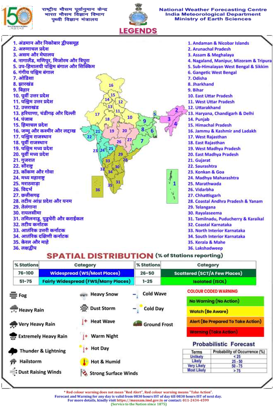
Legends & abbreviations:
- Heavy Rain:64.5115.5mm; Very Heavy Rain:115.6204.4mm; Extremely Heavy Rain: >204.4mm.
- Obsy: Observatory; Automatic Weather Station; ARG: Automatic Rain Gauge; dist: District: NH: National Highway; KVK: Krishi Vigyan Kendra; DVC: Damodar Valley Corporation; PTO: Part Time Office, Aero: Aerodrome, IAF: Indian Air Force.
- Region wise classification of meteorological Sub-Divisions:
- Northwest India: Western Himalayan Region (Jammu-Kashmir-Ladakh-Gilgit-Baltistan-Muzaffarabad, Himachal Pradesh and Uttarakhand); Punjab, Haryana Chandigarh & Delhi; West Uttar Pradesh, East Uttar Pradesh, West Rajasthan and East Rajasthan.
- Central India: West Madhya Pradesh, East Madhya Pradesh, Vidarbha and Chhattisgarh.
-
- East India: Bihar, Jharkhand, Sub-Himalayan West Bengal & Sikkim; Gangetic West Bengal, Odisha and Andaman & Nicobar Islands.
- Northeast India: Arunachal Pradesh, Assam & Meghalaya and Nagaland, Manipur, Mizoram & Tripura.
- West India: Gujarat Region, Saurashtra & Kutch, Coastal Maharashtra (Konkan) & Goa, Madhya Maharashtra and Marathawada.
- South India: Coastal Andhra Pradesh & Yanam, Telangana, Rayalaseema, Coastal Karnataka, North Interior Karnataka, South Interior Karnataka, Kerala & Mahe, Tamil Nadu, Puducherry & Karaikal and Lakshadweep.
****
NKR/JKP
(Release ID: 2285323)
|