Ministry of Science & Technology
Non-uniformity of Himalayas foresees significantly large earthquake events
Posted On:
09 APR 2021 4:50PM by PIB Delhi
Scientists have found that the Himalayas are not uniform and assume different physical and mechanical properties in different directions – a property present in crystals called anisotropy which could result in significantly large earthquake events in the Himalayas.
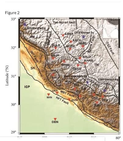
The NW region of India, an area covering Garhwal and Himachal Pradesh, has been hit by four destructive moderate to great earthquakes since the beginning of the 20th century -- the Kangra earthquake of 1905, the Kinnaur earthquake of 1975, the Uttarkashi earthquake of 1991, and the Chamoli earthquake of 1999. These seismic activities manifest large-scale subsurface deformation and weak zones, underlining the need for deeper insights into the ongoing deformation beneath these tectonically unstable zones.
Researchers from Wadia Institute of Himalayan Geology (WIHG), Dehradun, an autonomous institute under the Department of Science and Technology, Government of India, & Indian Institute of Technology Kharagpur (IIT KGP), namely Dr. Sushil Kumar, Scientist 'G', WIHG; Shubhasmita Biswal, Researcher, WIHG & IIT KGP; William Mohanty, Professor, IIT KGP, and Mahesh Prasad Parija, Ex-Researcher, WIHG used the data from WIHG to show that The North-West Himalayan region exhibits a peculiar characteristic present in crystals.
The joint study using seismic waves from 167 earthquakes recorded by 20 broadband seismic stations deployed in the Western Himalaya suggested that the major contribution of the anisotropy is mainly because the strain induced by the Indo-Eurasia collision (going on since 50 million years) and deformation due to the collision is found to be larger in the crust than in the upper mantle. It has been recently published in 2020 in the Journal ‘Lithosphere (GSA)’.
The inhomogeneity along the Himalayas influences the stressing rate is because of variation in the geometry of the Main Himalayan Thrust (MHT) system, and it controls the rupture size during the earthquake. This lack of homogenous physical and mechanical properties of the Himalayas could help explore new perspectives about deformations taking place at the Himalaya-Tibet crustal belt involved in the formation of the Himalayan Mountains.


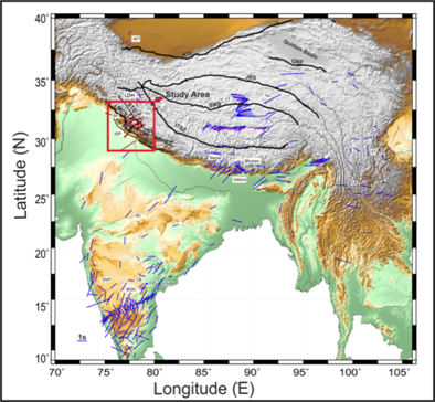
Figure: Map showing the fast polarization azimuths (Φ) and delay times (δt) from previous studies with blue bars and red bars indicates the average shear-wave splitting results from this study. The previous splitting measurements are obtained from http://splitting.gm.univmontp2. fr/DB. The study area is shown as a rectangle. Geological boundaries, in addition to those defined in Figure 2, include BNS (Bangong-Nujiang suture zone), JRS (Jinsha–River suture), ATF (Altyn Tagh fault), KF (Karakoram fault), QBF (Qaidam Basin fault), IGP: Indo-Gangetic plain, SH: Siwalik Himalaya, LH: Lesser Himalaya, HH: Higher Himalaya, TH: Tethys Himalaya, LDH: Ladakh Himalaya, ISC: Indian sub-continent, DVP: Deccan volcanic province, EDC: Eastern Dharwar craton, WDC: Western Dharwar craton, CB: Cuddapah basin, EMB: Eastern-Ghat Mobile Belt, WT: Western Tibet, CT: Central Tibet, ET: Eastern Tibet, ST: Southern Tibet, HCZ: Himalayan collision zone, CA: Central Asia, NEI: North-East India. The solid-filled circle and the length of the bar represent the stations location and the delay time, respectively.
Publication link: https://doi.org/10.2113/2020/8856812.
For more details, Dr. Sushil Kumar, Scientist ‘G’ & Head Geophysics, WIHG, Dehradun (sushil.rohella[at]gmail[dot]com, 9634223377) can be contacted.
****
RP (DST Media Cell)
(Release ID: 1710680)
Visitor Counter : 1749