Ministry of Earth Sciences
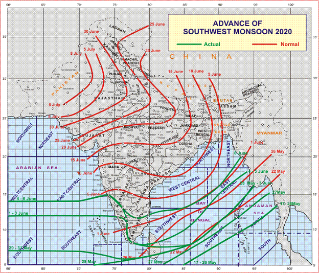
Southwest Monsoon advances into some more parts of South Interior Karnataka and Tamil Nadu, Puducherry & Karaikal; most parts of Bay of Bengal
Under the influence of the Western Disturbance, scattered to fairly widespread rain/thundershowers very likely to continue over western Himalayan region
Isolated to scattered rain/thundershowers over plains of northwest India during next 48 hours and decrease thereafter
Isolated thunderstorm accompanied with lightning and gusty wind are likely over these regions during next 24 hours
प्रविष्टि तिथि:
06 JUN 2020 8:18PM by National
According to the National Weather Forecasting Centre of the India Meteorological Department:
♦ Southwest Monsoon advanced into some more parts of South Interior Karnataka and Tamil Nadu, Puducherry & Karaikal; most parts of southwest Bay of Bengal, entire southeast Bay of Bengal; some more parts of eastcentral Bay of Bengal and some parts of westcentral & northeast Bay of Bengal.
♦ The Northern Limit of Monsoon (NLM) continues to pass through Lat.14°N/Long.60°E, Lat.14°N/Long.70°E, Karwar, Hassan, Salem, Puducherry, Lat.13°N/Long.85°E, Lat.16°N/Long.90°E and Lat.20°N/Long.93°E.
♦ Conditions are becoming favourable for further advancement of Southwest Monsoon into some more parts of Karnataka, entire Tamil Nadu; some parts of Rayalaseema and Coastal Andhra Pradesh; entire southwest Bay of Bengal; some more parts of central and northeast Bay of Bengal and some parts of northeast India during next 23 days.
♦ The cyclonic circulation over Bihar & adjoining East Uttar Pradesh extending upto 0.9 km above mean sea level persists.
♦ The Western Disturbance as a trough between 5.8 km and 7.6 km above mean sea level with its axis roughly along Long.78°E to the north of Lat.28°N persists.
♦ The cyclonic circulation over northwest Rajasthan & neighbourhood at 1.5 km above mean sea level persists.
♦ The cyclonic circulation over east Vidarbha & neighbourhood extending upto 0.9 km above mean sea level persists.
♦ The cyclonic circulation over eastcentral Bay of Bengal & adjoining north Andaman Sea between 3.1 km and 5.8 km above mean sea level persists.
♦ Under the influence of the Western Disturbance, scattered to fairly widespread rain/thundershowers very likely to continue over western Himalayan region and isolated to scattered rain/thundershowers over plains of northwest India during next 48 hours and decrease thereafter. Isolated thunderstorm accompanied with lightning and gusty wind are likely over these regions during next 24 hours.
♦ A Low Pressure Area is likely to develop over Eastcentral Bay of Bengal around 08th June, 2020.
Kindly visit www.mausam.imd.gov.in for updates on the system.
****
NB/KGS/(IMD release)
(रिलीज़ आईडी: 1629950)
आगंतुक पटल : 1040