Ministry of Earth Sciences
Severe Cyclonic Storm ‘NISARGA’ over coastal Mahrashtra- Cyclone Warning for north Maharashtra & adjoining south Gujarat coasts: Red message
Crossed Maharashtra coast close to south of Alibagh with a maximum sustained wind speed of 100-110 kmph gusting to 120 kmph between 1230-1430 hrs IST
Very likely to move northeastwards and weaken gradually into a Cyclonic Storm during next 06 hours
प्रविष्टि तिथि:
03 JUN 2020 4:29PM by PIB Delhi
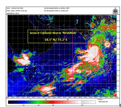
The Severe Cyclonic Storm ‘NISARGA’ over Eastcentral Arabian Sea moved northeastwards with a speed of about 23 kmph during past 06 hours, crossed Maharashtra coast close to south of Alibagh with a maximum sustained wind speed of 100-110 kmph gusting to 120 kmph between 1230-1430 hrs IST of today, the 03rd June. It lay centred at 1430 hours IST of today the 03rd June, 2020 over coastal Maharashtra, near latitude 18.5°N and longitude 73.2°E, close to east-southeast of Alibagh (Maharashtra), 75 km southeast of Mumbai (Maharashtra) and 65 km west of Pune (Maharashtra).
It is very likely to move northeastwards and weaken gradually into a Cyclonic Storm during next 06 hours.
The system is being continuously tracked by the Doppler Weather Radars (DWRs) at Mumbai (Maharashtra).
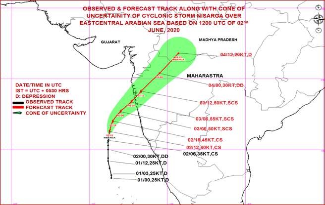
Forecast track and intensity are given in the following table:
|
Date/Time(IST)
|
Position
(Lat. 0N/ long. 0E)
|
Maximum sustained surface wind speed (Kmph)
|
Category of cyclonic disturbance
|
|
03.06.20/1430
|
18.5/73.2
|
90-100 gusting to 110
|
Severe Cyclonic Storm
|
|
03.06.20/1730
|
18.8/73.4
|
80-90 gusting to 100
|
Cyclonic Storm
|
|
03.06.20/2330
|
19.4/73.9
|
50-60 gusting to 70
|
Deep Depression
|
|
04.06.20/0530
|
20.2/74.6
|
40-50 gusting to 60
|
Depression
|
|
04.06.20/1130
|
20.8/75.1
|
30-40 gusting to 50
|
Depression
|
Warnings:
(i) Rainfall:
-
- Light to moderate rainfall at most places with heavy to very heavy falls at a few places and extremely heavy falls ( ≥ 20 cm in 24 hours) at isolated places very likely over north Konkan (Mumbai, Palghar, Thane, Raigad districts) and north Madhya Maharashtra during next 24 hours.
- Light to moderate rainfall at most places with heavy to very heavy falls at isolated places over south Konkan ( Ratnagiri & Sindhudurg districts) & Goa and south Gujarat region (Valsad, Navsari, Dang, Daman, Dadra & Nagar Haveli and Surat districts) during next 24 hours.
- Light to moderate rainfall at most places with heavy falls at isolated places over west Madhya Pradesh and Vidarbha during next 24 hours.
- Wind warning
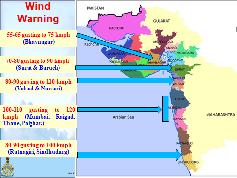
- Gale wind, speed reaching 90-100 kmph gusting to 110 kmph, is prevailing over Eastcentral Arabian Sea along & off north Maharashtra coast (Raigad, Mumbai and adjoining Thane), 60-80 kmph gusting to 90 kmph along & off Ratnagiri, Sindhudurg, Palghar and remaining areas of Thane. Gale wind, speed reaching 60-70 kmph gusting to 80 kmph, likely along & off Valsad, Navsari districts of Gujarat, Daman, Dadra & Nagar Haveli and along & off northeast Arabian Sea, Surat & Bharuch districts of south Gujarat during next 03 hours and will reduce gradually thereafter.
- Squally wind, speed reaching 50-60 kmph gusting to 70 kmph is likely to prevail over northeast Arabian Sea along & off remaining districts of south Gujarat coast during next 03 hours and will reduce gradually thereafter.
- Squally wind, speed reaching 50-60 kmph gusting to 70 kmph is likely prevail over eastcentral Arabian Sea along and off Karnataka-Goa coasts during next 06 hours and will reduce gradually thereafter.
(iii) Sea condition
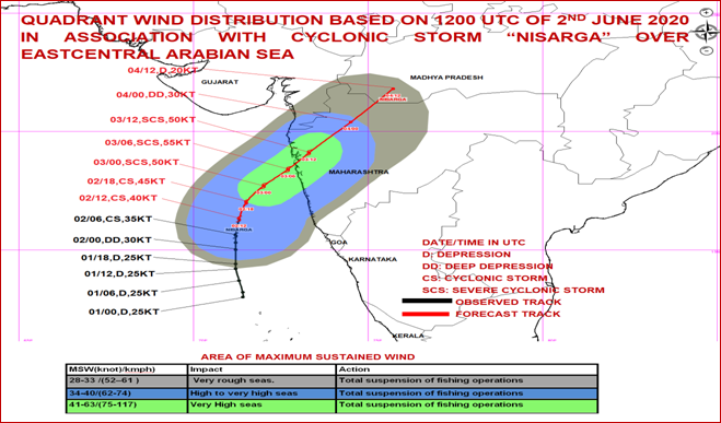
The Sea condition will be High to Very High over eastcentral Arabian Sea and along & off Maharashtra & Goa coasts till today, the 3rd June evening. The Sea condition is very likely to be very rough to High over northeast Arabian Sea along & off south Gujarat coast till today, the 3rd June evening
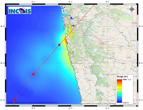
(iv) Storm Surge Warning:
Storm surge of about 0.5 to 1 meter height above astronomical tide is very likely to inundate low lying areas of Mumbai, Thane and Raigad districts during next 3 hours.
(v) Fishermen Warning
Fishermen are advised not to venture into Eastcentral and Northeast Arabian Sea and along & off Karnataka-Goa-Maharashtra-south Gujarat coasts during next 12 hours.
- Damage Expected:
- Major damage to thatched houses/ huts. Roof tops may blow off. Unattached metal sheets may fly.
- Damage to power and communication lines.
- Major damage to Kutcha and some damage to Pucca roads. Flooding of escape routes.
- Breaking of tree branches, uprooting of large avenue trees. Damage to banana and papaya trees. Large dead limbs blown from trees.
- Major damage to coastal crops.
- Damage to embankments/ salt pans.
(vii) Fishermen Warning & Action Suggested:
- Total suspension of fishing operations.
- Mobilise evacuation from low lying areas.
- Judicious regulation of rail and road traffic.
- People in affected areas to remain indoors.
- Movement in motor boats and small ships unsafe.
Post Landfall Outlook:
The Severe Cyclonic Storm is very likely to weaken gradually into a Cyclonic Storm during next 06 hours, while moving north-northeastwards across north Madhya Maharashtra. Under its influence, Gale wind reaching 60-70 kmph gusting to 80 kmph very likely to prevail over Pune, Ahmadnagar and 55-65 kmph gusting to 75 kmph adjoining Beed, Nashik & Aurangabad districts of Maharashtra. Light to moderate rainfall at most places with heavy to very heavy falls at isolated places are also very likely over these districts on 3rd June, 2020.
Damage Expected and Action suggested for interior districts of Maharashtra (Pune, Ahmadnagar, Nashik, Aurangabad and adjoining Beed).
(i) Minor damage to power and communication lines. (ii) Damage to Kutcha and some damage to Pucca roads. (iii) Breaking of tree branches, uprooting of small trees. (iv) Damage to banana and papaya trees. (v) People in affected areas to remain indoors.
Legend: ECA- east-Central Arabian Sea
DOPPLER WEATHER RADAR MUMBAI AT 14:39:13 HOURS IST OF 03.06.2020
The below listed surge heights over and above astronomical tide.
|
MANDAL/TALUK
|
DISTRICT
|
STATE / UNION TERRITORY
|
NEAREST PLACE OF HABITATION
|
* STORM SURGE
(m)
|
* EXPECTED INUNDATION EXTENT (km)
|
|
ALIBAG
|
RAIGAD
|
MAHARASHTRA
|
ALIBAG
|
0.5-1.3
|
Around 1.4
|
|
DAPOLI
|
RATNAGIRI
|
MAHARASHTRA
|
DAPOLI
|
0.6-0.9
|
Around 0.3
|
|
PEN
|
RAIGAD
|
MAHARASHTRA
|
PEN
|
0.7-0.9
|
Around 2.2
|
|
THANE
|
GREATER MUMBAI
|
MAHARASHTRA
|
THANE
|
0.7-0.9
|
Around 0.3
|
Kindly visit www.rsmcnewdelhi.imd.gov.in and www.mausam.imd.gov.in for updates on the system.
*****
NB/KGS/(IMD releases
(रिलीज़ आईडी: 1629018)
आगंतुक पटल : 534