Ministry of Earth Sciences
Update at 1730 Hrs IST: Super Cyclonic Storm ‘AMPHAN’ over west-central and adjoining central parts of South Bay of Bengal: Cyclone Warning for West Bengal and north Odisha coasts: Orange Message
Posted On:
18 MAY 2020 3:46PM by PIB Delhi
According to the latestrelease (at 1730 Hrs. IST)by the Cyclone Warning Divisionof the India Meteorological Department:
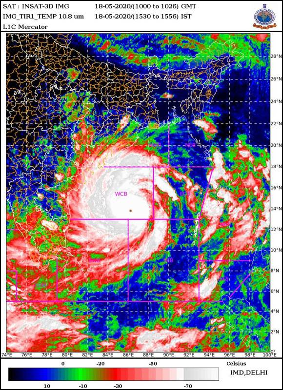
The Super Cyclonic Storm‘AMPHAN’ (pronounced as UM-PUN) over west-central and adjoining central parts of South Bay of Bengal moved nearly northwards with a speed of 07 kmph during past 06 hoursand lay centred at 1430 hrs IST of today, the 18th May, 2020 over Westcentral and adjoining central parts of South Bay of Bengal near latitude 13.7°N and longitude 86.2 °E, about 730 km nearly south of Paradip (Odisha), 890 km south-southwest of Digha (West Bengal) and 1010 km south-southwest of Khepupara (Bangladesh).
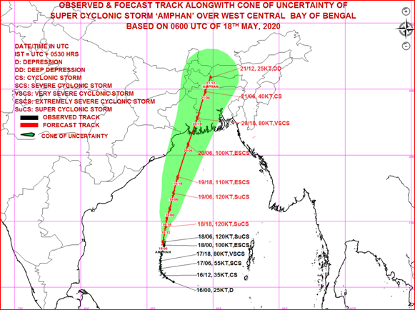
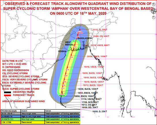
It is very likely to move nearly northwards for some more time and then north-northeastwards across northwest Bay of Bengal and cross West Bengal – Bangladesh coasts between Digha (West Bengal) and Hatiya Islands (Bangladesh) close to Sundarbans during the Afternoon / Evening of 20th May 2020 as anExtremely Severe Cyclonic Storm with maximum sustained wind speed of 165-175 kmph gusting to 185 kmph.
Forecast track and intensity are given in the following table:
|
Date/Time(IST)
|
Position
(Lat. 0N/ long. 0E)
|
Maximum sustained surface
wind speed (Kmph)
|
Category of cyclonic disturbance
|
|
18.05.20/1430
|
13.7/86.2
|
220-230 gusting to 255
|
Super Cyclonic Storm
|
|
18.05.20/1730
|
14.6/86.4
|
230-240 gusting to 265
|
Super Cyclonic Storm
|
|
18.05.20/2330
|
15.2/86.5
|
230-240 gusting to 265
|
Super Cyclonic Storm
|
|
19.05.20/0530
|
15.9/86.7
|
230-240 gusting to 265
|
Super Cyclonic Storm
|
|
19.05.20/1130
|
17.1/87.0
|
220-230 gusting to 255
|
Super Cyclonic Storm
|
|
19.05.20/2330
|
18.3/87.3
|
200-210 gusting to 230
|
Extremely Severe Cyclonic Storm
|
|
20.05.20/1130
|
20.8/88.1
|
180-190 gusting to 210
|
Extremely Severe Cyclonic Storm
|
|
20.05.20/2330
|
22.8/88.8
|
145-155 gusting to 170
|
Very Severe Cyclonic Storm
|
|
21.05.20/1130
|
24.8/89.4
|
80-90 gusting to 100
|
Cyclonic Storm
|
|
21.05.20/1730
|
25.9/89.8
|
40-50 gusting to 60
|
Depression
|
(1) Heavy rainfall Warning:
Odisha: Coastal Odisha is likely to experience light to moderate rainfall at many places from today evening with heavy falls at isolated places over coastal Odisha (Gajapati, Ganjam, Puri, Jagatsinghpur&Kendrapara Districts) on 18th May, 2020. Rainfall at most places with heavy to very heavy rainfall at a few places over north coastal Odisha (Jagatsinghpur, Kendrapara, Jajpur, Balasore, Bhadrak& Mayurbhanj Districts) and isolated heavy falls over Khordha&Puri districts on 19th May and isolated heavy rainfall over north Odisha (Bhadrak, Balasore, Mayurbhanj, Jajpur, Kendrapara and Keonjhar Districts) on 20th May 2020.
West Bengal
Coastal districts of Gangetic West Bengal (East Medinipur, South & North 24 Parganas) are likely to experience light to moderate rainfall at many places with heavy falls at isolated places on 19th May. Rainfall at most places with heavy to very heavy falls at a few places & extremely heavy falls at isolated places likely over Gangetic West Bengal (east & west Medinipur, south & north 24 Parganas, Howrah, Hoogli, Kolkata and adjoining districts)on 20th May and isolated heavy rain over interior districts on 21st May, 2020.
Sub-Himalayan West Bengal and Sikkim
Light to moderate rainfall at most places with heavy to very heavy falls at a few places over Malda& Dinajpur districts on 20th May and over most of the districts of Sub-Himalayan West Bengal & Sikkim on 21st May, 2020.
Assam & Meghalaya
Light to moderate rainfall at most places with heavy to very heavy falls at a few places over the western districts of Assam & Meghalaya on 21st May.
(2) Wind warning
West Bengal & Odisha
- Squally wind speed reaching 45 to 55 kmph gusting to 65 kmph is likely to commence along and off south Odisha coast from 18th evening, increase becoming 55 to 65 kmph gusting to 75 kmph extend to along & off north Odisha coast from 19th morning and along and off West Bengal coast from 19th afternoon.
- The wind speed will gradually increase becoming gale wind speed reaching 75 to 85 kmph gusting to 95 kmph from 20th morning along and off north Odisha (Jagatsinghpur, Kendrapara, Bhadrak, Balasore and Mayurbhanj districts) and West Bengal (east & west Medinipur, south & north 24 Parganas, Howrah, Hoogli, Kolkata Districts). It will gradually increase thereafter becoming 110 to 120 kmph gusting to 135 kmph along & off the above mentioned districts of North Odisha.
- Gale wind speed reaching 165 to 175 kmph gusting to 195 kmph very likely along & off east Medinipur and north & south 24 Parganas districts and 100-110 kmph gusting to 120 kmph over Kolkata, Hoogli, Howrah and West Mednipur Districts of West Bengal during the time of landfall (20th afternoon to night).
- Squally wind speed reaching 55-65 kmph gusting to 75 kmph likely to prevail over Puri, Khordha, Cuttack, Jajpur districts of Odisha during 20th May 2020.
Deep Sea area
- Gale wind speed reaching 220-230 gusting to 255 kmph is prevailing over west-central and adjoining central parts of south Bay of Bengal. It is likely to increase becoming 220-230 gusting to 255 kmph over northern parts of central Bay of Bengal and adjoining North Bay of Bengal from tonight to 19th May morning, likely to increase further becoming 230-240 gusting to 265 kmph by tonight.
- Gale wind speed reaching 220-230 gusting to 255 kmph over north Bay of Bengal from 19th morning and gradually decrease becoming 155- 165 kmph gusting to 180 kmph by 20th evening.
(3) Sea condition: Sea condition will be Phenomenal over west-central and adjoining central parts of south Bay of Bengal during next 24 hours. It will become Phenomenal overnorthern parts of central Bay of Bengal and adjoining north Bay of Bengal on 19th May and over north Bay of Bengal on 20th May 2020.
(4) Fishermen Warning
- The fishermen are advised not to venture into west-central and adjoining central parts of south Bay of Bengal during next 24 hours, to central Bay of Bengal on 19th May and into North Bay of Bengal during 19th to 20th May 2020.
- Also, fishermen are advised not to venture into North Bay of Bengal along and off North Odisha, West Bengal and adjoining Bangladesh coasts during 18th to 20th May 2020.
(5)Storm Surge expected
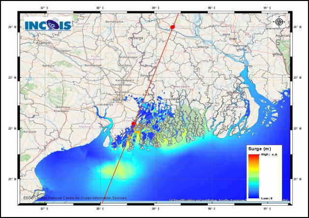
- Storm Surge of about 4-5 meters above Astronomical Tide is likely to inundate low lying areas of south & north 24 Parganas and about 3-4 meters over the low lying areas of East Medinipur District of West Bengal during the time of Landfall. (Figure enclosed)
(6)Damage Expected and Action suggested
(a) West Bengal (east Medinipur, south & north 24 Parganas, Howrah, Hoogli, Kolkata districts)
Damage Expected:
- Extensive damage to all types of kutcha houses, some damage to old badly managed Pucca structures. Potential threat from flying objects.
- Extensive uprooting of communication and power poles.
- Disruption of rail/road link at several places.
- Extensive damage to standing crops, plantations, orchards.
- Blowing down of Palm and coconut trees.
- Uprooting of large bushy trees.
- Large boats and ships may get torn from their moorings.
Fishermen Warning & Action Suggested:
- Total suspension of fishing operations during 18th to 20th May 2020.
- Diversion or suspension of rail and road traffic.
- People in affected areas to remain indoors. Mobilise evacuation from Low lying areas.
- Movement in motor boats and small ships not advisable.
(b) Odisha (Jagatsinghpur, Kendrapara, Bhadrak, Balasore, Jajpur& Mayurbhanj)
Damage Expected:
- Total destruction of thatched houses/ extensive damage to kutcha houses. Potential threat from flying objects.
- Bending/ uprooting of power and communication poles.
- Major damage to Kutcha and Pucca roads. Minor disruption of railways, overhead power lines and signalling systems.
- Widespread damage to standing crops, plantations, orchards, falling of green coconuts and tearing of palm fronds. Blowing down of bushy trees like mango.
- Small boats, country crafts may get detached from moorings.
Fishermen Warning & Action Suggested:
- Total suspension of fishing operations during 18th to 20th May 2020.
- Diversion or suspension of rail and road traffic.
- People in affected areas to remain indoors.
- Movement in motor boats and small ships not advisable.
Kindly visit www.rsmcnewdelhi.imd.gov.in and www.mausam.imd.gov.in for updates on the system.
(See graphic/ pictures below)
|
Super Cyclonic Storm ‘AMPHAN’ 13.7 0N/86.2 0E

|


Figure: Storm Surge forecast from INCOIS
Storm Surge of about 4-5 meters above Astronomical Tide is likely to inundate low lying areas of south & north 24 Parganas and about 3-4 meters over the low lying areas of East Medinipur District of West Bengal during the time of Landfall.
****
KGS/(IMD release)
(Release ID: 1624864)
Visitor Counter : 1087