Ministry of Science & Technology
"National Geospatial Policy 2022" marked a landmark reform that democratized access to geospatial data, liberalised the sector: Dr Jitendra Singh
GeodCon-26 Highlights India’s Growing Leadership in Geospatial Science; Dr Jitendra Singh Stresses Strategic Importance of Geodesy
NavIC, Space Missions and Earth Observation Programmes Reflect India’s Expanding Role in Global Geospatial Ecosystem, says Union Minister
DST and Survey of India Strengthening India’s Geospatial Infrastructure and Geodesy Research: Dr Jitendra Singh
प्रविष्टि तिथि:
12 MAR 2026 7:45PM by PIB Delhi
India is moving decisively toward scientific self-reliance under the vision of Aatmanirbhar Bharat, and in this transformative decade foundational sciences such as geodesy must emerge as strategic national strengths, said Union Minister of State (Independent Charge) for Science & Technology and Earth Sciences, MoS PMO, Personnel, Public Grievances, Pensions, Atomic Energy and Space, Dr. Jitendra Singh, adding that "National Geospatial Policy 2022" marked a landmark reform that democratized access to geospatial data and liberalised the sector.
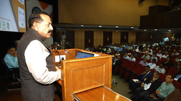
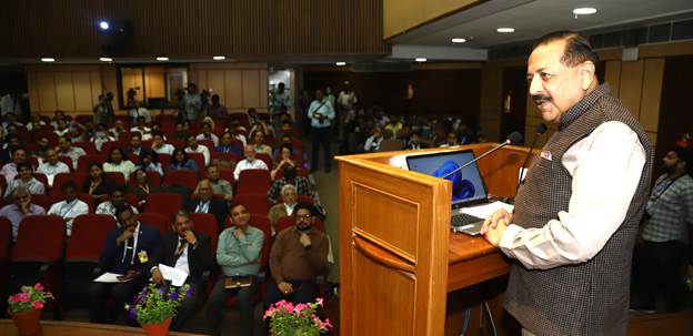
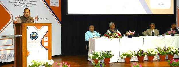
The Minister was addressing the inaugural session of GeodCon-26, the first National Conference on Geodesy, at INSA, New Delhi.
Dr Jitendra Singh underlined that the geospatial sector today plays a pivotal role across governance, infrastructure development, national security, disaster resilience and economic growth. He said that geodesy forms the scientific backbone of this expanding geospatial ecosystem, enabling accurate positioning, satellite navigation, infrastructure planning, climate monitoring and disaster response.
Union Minister noted that the National Geospatial Policy 2022 marked a landmark reform that liberalised the sector, democratized access to geospatial data and encouraged innovation and private participation. He said that the geospatial domain is increasingly becoming an enabling layer for multiple sectors of the economy, strengthening governance as well as national development.
Highlighting the scientific significance of geodesy, the Minister said that while mapping represents the visible layer of development, geodesy remains the invisible but essential scientific foundation that makes it possible. He emphasised that a technologically advanced nation must maintain sovereign capability over its geodetic reference frames, gravity models and positioning systems.
Referring to India’s growing technological capabilities, Dr. Jitendra Singh said that initiatives such as the indigenous navigation system NavIC, space missions and Earth observation programmes reflect the country’s expanding role in the global geospatial ecosystem. He noted that the success and accuracy of such systems are closely linked with strong geodetic infrastructure and reference frameworks.
The Minister also highlighted the importance of collaboration among government institutions, academia, industry and young researchers to strengthen India’s geospatial capabilities. He said platforms such as GeodCon-26 provide an important opportunity for dialogue, networking and collaboration among stakeholders working in the field.
Union Minister further appreciated the ongoing efforts of the Department of Science and Technology and the Survey of India in strengthening the country’s geospatial infrastructure and promoting scientific research in geodesy. He also welcomed the large participation of young scholars and researchers, noting that capacity building and development of skilled manpower will be essential for building a strong and self-reliant geospatial ecosystem in the country.
Padma Shri Dr. V. P. Dimri, Patron of GeodCon-26, said that geodesy has long remained a foundational science that is essential yet often unnoticed, and it is encouraging to see it now receiving focused scientific attention through a national conference dedicated to the field. He highlighted the importance of sustained scientific investment and welcomed the establishment of the National Centre for Geodesy at IIT Kanpur along with six Regional Centres, noting that the initiative represents an integrated national effort to strengthen geodetic science, research and capacity building in the country.
Speaking on the occasion, Dr.M.Mohanty, Head of the NGP Division at the Department of Science and Technology, highlighted the growing importance of geodesy in the context of the upcoming geospatial mission and national geospatial infrastructure. He said the National Centre for Geodesy has enabled research in areas such as GNSS-based reference frame development, crustal deformation monitoring, space geodesy techniques and GeoAI-based applications, while also supporting training programmes and advanced geospatial data processing capabilities.
GeodCon-26 brings together scientists, policymakers, industry leaders, academic institutions and young researchers to deliberate on advancements in geodesy and its applications in national development, scientific research and strategic sectors.
The inaugural session also featured addresses by Dr. Onkar Dikshit, Chairperson, GeodCon-26, and Shri Hitesh Kumar S. Makwana, Surveyor General of India
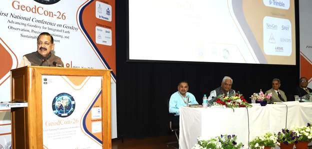
PHOTO: Union Minister Dr. Jitendra Singh addressing the inaugural session of GeodCon-26, the first National Conference on Geodesy, at INSA, New Delhi on Thursday.
****
NKR/FK/AV
(रिलीज़ आईडी: 2239150)
आगंतुक पटल : 1234