Ministry of Science & Technology
UN-GGIM-AP conference underlines importance of regional co-operation for strengthening geospatial capabilities
Posted On:
26 NOV 2024 4:07PM by PIB Delhi
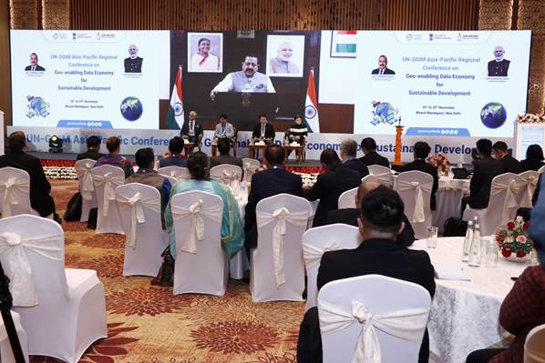
Union Minister of State (Independent Charge) for Science and Technology, Minister of State (Independent Charge) for Earth Sciences, MoS PMO, Department of Atomic Energy, Department of Space, Personnel, Public Grievances and Pensions, Dr. Jitendra Singh, highlighted the importance of regional collaboration in ensuring that best practices and use cases are exchanged to manage our resources effectively and responsibly through a video message at the UN-GGIM-AP Conference on Geo-Enabling Data Economy for Sustainable Development and 13th UN-GGIM-AP Plenary Meeting.
VPNY.jpeg)
The UN-GGIM Asia-Pacific Conference on Geo-enabling Data Economy for Sustainable Development which was inaugurated today at the Bharat Mandapam in New Delhi, brought together leading experts, policymakers, and geospatial professionals from the Asia and the Pacific region. It featured collaborative session with experts from Europe, Americas, Arab States and Africa.
“India is deeply committed to strengthening the Asia-Pacific region’s geospatial capabilities through UNGGIM-AP. By working together, we can share best practices, develop common standards, and support each other in addressing the unique challenges faced by our region—be it rapid urbanization, environmental degradation, or the increasing frequency of natural disasters,” the Union Minister pointed out while inaugurating the event scheduled from 26 to 29 November 2024.
He stressed that the Asia-Pacific region is home to diverse economies and cultures, and effective use of geospatial data can help ensure inclusive development, equitable access to resources, and sustainable growth for all and that India is deeply committed to strengthening the Asia-Pacific region’s geospatial capabilities through UNGGIM-AP.
Dr Singh underlined that India has actively participated in regional initiatives and is open to collaborating with all member countries to share knowledge, expertise, and technology. “We are committed to building an open, transparent, and inclusive geospatial ecosystem that can drive sustainable development across our region. I look forward to engaging with all of you as we move forward on this journey. Together, we can create a future that is data-driven, sustainable, and equitable for all,” he added.

With approximately 90 international delegates from 30 countries, along with 120 delegates from India, it will provide a platform for sharing knowledge, discussing advancements in geospatial technology, and fostering collaboration between member nations and other regional committees of UN-GGIM.
Delegates from reputed global organizations such as the International Association of Geodesy (IAG), the International Federation of Surveyors (FIG), and the United Nations Global Geospatial Knowledge and Innovation Centre (UN-GGKIC), United Nations Global Geodetic Centre of Excellence (UN-GGCE) will attend the event that will promote exchange of global best practices, discussions on emerging geospatial technologies, and the formulation of regional strategies to enhance the use of geospatial information for realizing the sustainable development goals.
“To truly harness the power of geospatial data, it is essential that stakeholders—governments, businesses, and civil society—collaborate, invest in the necessary infrastructure, and ensure that data is accessible and usable by all. With the right approach, geo-enabling the data economy can play a central role in achieving the global sustainable development agenda and ensuring a better future for generations to come,” said DST Secretary Professor Abhay Karandikar.
“The conference can show the way for harnessing geospatial technologies and integration of data resources for long term long term sustainable development and meeting the UN sustainable development goals,” said Mr. Antonius Bambang Wijanarto, President UN-GGIM-AP.
“The discussions at the 4-day event could help formulating regional strategies, and harnessing the power of geospatial data to achieve Sustainable Development Goals (SDGs). Together, we can address shared challenges and build a sustainable future for all”, said Surveyor General of India, Shri Hitesh Kumar S. Makwana at the conference.
The event will strengthen the role of geospatial data in addressing common challenges at global, regional and country level.
******
NKR/KS
(Release ID: 2077449)
Visitor Counter : 1155