Ministry of Earth Sciences
Seismic Mapping
प्रविष्टि तिथि:
30 JUL 2021 2:27PM by PIB Delhi
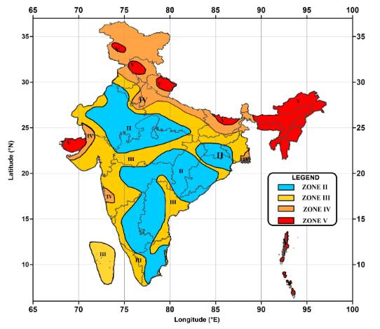
Minister of State (I/C) for Science & Technology and Earth Sciences, Shri Jitendra Singh informed the Lok Sabha today in a written reply that, considering the recorded history of earthquakes in the country, a total of ~59% of the land mass of India (covering all states of India) is prone to earthquakes of different intensities. As per the seismic zoning map of the country, the total area is classified into four seismic zones. Zone V is seismically the most active region, while zone II is the least. Approximately, ~ 11% area of the country falls in zone V, ~18% in zone IV, ~ 30% in zone III and remaining in zone II.
List of important cities/towns of India that fall under the high seismic zones of IV
and V, State/UT-wise, are given in table below:
|
City/Town
|
State/UT
|
Zone
|
City/Town
|
State/UT
|
Zone
|
|
Almora
|
Uttrakhand
|
IV
|
Jorhat
|
Assam
|
V
|
|
Ambala
|
Haryana
|
IV
|
Jalpaiguri
|
West Bengal
|
IV
|
|
Amritsar
|
Punjab
|
IV
|
Kooch Bihar
|
West Bengal
|
IV
|
|
Baharich
|
Utter Pradesh
|
IV
|
Kohima
|
Nagaland
|
V
|
|
Barauni
|
Bihar
|
IV
|
Kolkata
|
West Bengal
|
IV
|
|
Bhuj
|
Gujarat
|
V
|
Ludhiana
|
Punjab
|
IV
|
|
Bulandshahr
|
Uttar Pradesh
|
IV
|
Mandi
|
Himanchal Pradesh
|
V
|
|
Chandigarh
|
Chandigarh
|
IV
|
Monghyr
|
Bihar
|
IV
|
|
Darbhanga
|
Bihar
|
V
|
Moradabad
|
Uttar Pradesh
|
IV
|
|
Darjeeling
|
West Bengal
|
IV
|
Nainital
|
Uttrakhand
|
IV
|
|
Dehradun
|
Uttrakhand
|
IV
|
Patna
|
Bihar
|
IV
|
|
Deoria
|
Uttar Pradesh
|
IV
|
Parganas
|
West Bengal
|
IV
|
|
Delhi
|
Delhi
|
IV
|
Pilibhit
|
Uttar Pradesh
|
IV
|
|
Dinajpur
|
West Bengal
|
IV
|
PortBlair
|
Andaman & Nicobar
|
V
|
|
Ghaziabad
|
Uttar Pradesh
|
IV
|
Roorkee
|
Uttrakhand
|
IV
|
|
Gangtok
|
Sikkim
|
IV
|
Sadiya
|
Assam
|
V
|
|
Guwahati
|
Assam
|
V
|
Simla
|
Himanchal Pradesh
|
IV
|
|
Gorakhpur
|
Uttar Pradesh
|
IV
|
Srinagar
|
Jammu & Kashmir
|
V
|
|
Imphal
|
Manipur
|
V
|
Tezpur
|
Assam
|
V
|
National Centre for Seismology under Ministry of Earth Sciences is the nodal agency of Government of India (GoI), for monitoring earthquakes in and around the country. For this purpose, NCS maintains a National Seismological Network (NSN) consisting of 115 observatories spread across the country. The information of earthquakes reported by NCS is being disseminated to the concerned central and state disaster authorities in least possible time to initiate the adequate mitigation measures.
Secondly, Seismic Microzonation of cities in India having population of 5 Lakh and above is also considered. The purpose is to generate inputs for constructing earthquake risk resilient buildings / structures to reduce and mitigate the impacts of earthquake shaking and for minimising the damages to structures and loss of lives for safer urban planning.
Additionally, National Disaster Management Authority (NDMA) of Indiais engaged with conducting regular awareness campaigns every year through print, electronic as well as social media from time to time to sensitize programs on prevention and preparedness for building safety from earthquakes.
Beside, Government of India is poised to follow guidelines by the Bureau of Indian Standards (BIS), Building Materials & Technology Promotion Council (BMTPC) and Housing and Urban Development Corporation (HUDCO) etc. for design and construction of earthquake risk resistant structures to minimize the loss of life and damage to property caused by earthquakes. These guidelines are in wide circulation amongst the public and the administrative authorities responsible for the design and construction of earthquake resistant structures in earthquake prone areas.
Seismic Zonation map of the country (state wise) given by Bureau of Indian Standards (BIS) has categorised into several seismic zones (Zone II to Zone V) with variability of peak ground acceleration (PGA) (0.16g to > 0.36g) with of 10% of exceedance in PGA in 50-years as shown in figure below. According to this map the state of West-Bengal falls under Zone IV, III and II. Larger portion of West-Bengal state lies in Zone III. For the state of Uttar-Pradesh the state lies in Zone IV, III and II.

The seismic zones of the entire country including West Bengal are classified based upon the empirical seismic attenuation law with respect to the maximum credible earthquake source zone located at the vicinity of the area under study, which has further corroborated with historical seismicity and ground motions of the earthquakes observed in various parts of the country in past. This data was analysed by Bureau of Indian Standards to prepare a Probabilistic Seismic Hazard Zonation Map of India.
*****
SNC / TM / RR
(रिलीज़ आईडी: 1740656)
आगंतुक पटल : 110903
इस विज्ञप्ति को इन भाषाओं में पढ़ें:
Urdu
,
Tamil