PIB Backgrounder
Navigating India’s Waterways: Building a Safer, Smarter Network
Posted On:
16 OCT 2026 12:07PM by PIB Delhi
|
India is building a safer and smarter inland navigation ecosystem as waterway traffic expands. Hydrographic surveys and fairway maintenance keep channels navigable, while India’s first riverine lighthouses on the Brahmaputra add long-range support for 24×7 navigation. Digital platforms provide real-time depth, route and weather information. Together, these interventions are strengthening navigation safety, improving predictability and supporting the growing movement of cargo across India’s waterways.
|
Strengthening Navigation as Waterways Expand
India’s rivers and waterways are gaining a larger role in the country’s transport network. They are being energised as a force multiplier for the economy, offering a cost-efficient and cleaner mode for transportation. Moving a tonne of freight by water costs roughly one-third of road transport and half of rail. It also generates a fraction of the carbon emissions. This eases pressure on highways and reserves them for passengers and time-sensitive goods.
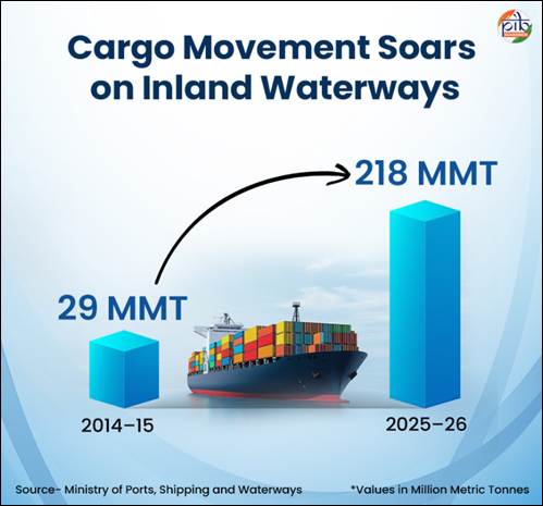
The country has 111 National Waterways (NW) to promote shipping and navigation. The total length of these waterways is 20,187 km, spread across 23 States and 4 Union Territories. Of these, 32 National Waterways are currently operational. The growing economic value of waterways is reflected in their rapidly increasing freight movement. Cargo movement on inland waterways rose from 29 million metric tonnes (MMT) in 2014–15 to 218 MMT in 2025–26. This represents a Compound Annual Growth Rate (CAGR) of 20.13%. The growth has already surpassed the target of 200 MMT set under Maritime India Vision 2030. Inland waterways are therefore moving from potential to performance.
This expansion of waterways is making it necessary to provide for safer and smarter navigation support and infrastructure that help understand river conditions and navigability across routes. Hydrographic surveys and fairway maintenance are being done to help vessels navigate changing river conditions. Digital platforms are providing information on depths, routes, vessel movement and weather. New navigation infrastructure, including India’s first riverine lighthouses, is adding further support for round-the-clock movement.
Hydrographic Surveys: Knowing the Rivers
A river may appear unchanged from the surface, but the structure of its navigable channel is not visible from outside. Water levels also vary across seasons and river stretches. These changes can affect the route available to vessels. For this reason, inland waterway development requires continuous knowledge of river conditions.
Hydrographic surveys
Hydrography involves measuring and describing water bodies and their physical features, like structure of the bed, water depth, flow direction and possible hazards. The purpose is to support navigation and other activities like offshore operations, scientific research, environmental protection and forecasting services. A key objective of hydrographic surveys is to produce navigation charts and maps that provide a clear, comprehensive and updated picture of the surveyed area.
The Inland Waterways Authority of India conducts hydrographic surveys across National Waterways. These surveys measure and analyse river depths, bed profiles, shoals, flow characteristics and morphological changes affecting navigability. These include thalweg surveys that identify and monitor the deepest navigable channel along the river stretch. Terminal & jetty surveys assess depth and approach conditions near terminals and jetties, etc. Continuous hydrographic assessment supports navigational channel (fairway) development, dredging plans, navigational safety and informed decisions for inland water transport (IWT) infrastructure development across the country.
|
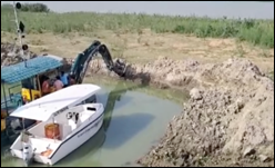
Dredging is the process of removing sediments from the bottom of water bodies. Dredging work is carried out across stretches of National Waterways in order to improve their navigability.
|
River conditions can change rapidly in some stretches. Survey frequency therefore varies according to the requirements of individual waterways. As of September 2026, regular thalweg surveys covered 22 National Waterways. Surveys are conducted weekly, fortnightly or monthly, depending on the waterway. The Indian portion of Indo-Bangladesh Protocol route was also covered under this monitoring system. This is an inland water transit network that enables cargo movement between India and Bangladesh through designated river routes.
Least Available Depth: A Critical Navigation Parameter
One of the most important outputs of hydrographic surveys is the Least Available Depth (LAD). LAD refers to the minimum depth of water available in a navigation channel. It is assessed for a particular stretch and a specific period. LAD directly influences vessel operations and navigation planning. It determines the permissible vessel draft and influences cargo-carrying capacity. It also supports route scheduling and seasonal navigation decisions.
Aids to Navigation: Guiding Vessels Safely
Safe navigation depends on reliable systems that help vessels identify routes, hazards and changing conditions. Under the Marine Aids to Navigation Act, 2021, these systems are formally recognised as Aids to Navigation (AtoN).
An AtoN is a device, system or service external to vessels that is designed and operated to enhance safe and efficient navigation of individual vessels and vessel traffic. These include lighted buoys, radar beacons, lamp posts, channel markers, lighthouses, lightships, etc.
|
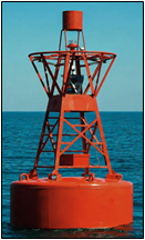
Buoys- Floating objects anchored at a definite location to guide or warn mariners, to mark positions of submerged objects, or to moor vessels in lieu of anchoring. Type of buoys include lateral marks, cardinal marks, isolated danger marks, safe water marks, special marks, emergency wreck marking buoy.
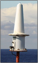
Radar beacon (Racon)- Highly responsive, single piece device used by ports and harbor authorities to help mariners easily identify the location of fixed or floating Aids to Navigation. The device transmits in almost any type of weather, unaffected by fog or poor weather and sea conditions.
|
The Directorate General of Lighthouses and Lightships (DGLL) is responsible for the development, maintenance and management of general AtoN along India’s coastline. It also serves as the national authority for training on AtoN and Vessel Traffic Services (VTS). India is a signatory to the International Convention for the Safety of Life at Sea (SOLAS), which requires contracting governments to develop and operate appropriate aids to navigation. India also follows the recommendations and guidelines on Aids to Navigation (AtoN) issued by the International Organization for Marine Aids to Navigation (IALA).
Across the national waterways, IWAI maintains a robust system of AToN. Different waterways use different combinations of these aids based on navigation requirements. National Waterway-3 is a strong example of this infrastructure. NW-3, located in the State of Kerala, forms a critical component of the country’s inland water transport network. The West Coast Canal system, connects Kottapuram to Kollam and extends through the Champakkara and Udyogamandal Canals. The entire navigable stretch is equipped with AtoN to support 24×7 navigation. A total of 312 solar-powered lighted FRP (Fiberglass Reinforced Plastic) buoys and 17 beacon lamp posts are deployed along this waterway.
Riverine Lighthouses: Bringing 24×7 Navigation Support
India’s inland navigation system entered new territory in March 2026. India announced its first four riverine lighthouses on the Brahmaputra, designated as National Waterway-2. The development marks a significant step in strengthening Aids to Navigation on inland waterways. The four lighthouses are being established at Pandu, Bogibeel, Silghat and Biswanath Ghat. The ₹74-crore project will combine navigational guidance with modern monitoring capabilities.
- The lighthouses will rise 20 metres above ground, providing prominent navigational reference points.
- Their geographical range will extend to 14 nautical miles, supporting wider navigational visibility.
- Their luminous range will extend between 8 and 10 nautical miles, aiding night-time vessel movement.
- Powered entirely by solar energy, it will provide a clean and reliable source for lighthouse operations.
- Weather-observation sensors will provide additional information relevant to navigation and safety.
- The complexes will also feature museums, amphitheatres, cafeterias and landscaped public spaces.
- Children’s play areas and souvenir shops will add public and tourism-oriented facilities.
Why This Matters for the Brahmaputra
The initiative marks the first deployment of lighthouse infrastructure on an inland waterway in India. It brings a new navigation-safety mechanism to a river corridor with growing transport activity. NW-2 connects Assam's Dhubri to Sadiya across a navigable length of 891 kilometres. It is the longest navigable stretch of any Indian waterway.
The waterway supports movement of cargo, passengers and tourists across the region. It also serves supply chains associated with tea, coal and fertiliser. Cargo movement on NW-2 increased from 0.90 million metric tonnes (MMT) in FY 2024–25 to 1.29 MMT in FY 2025–26. This reinforces the need for stronger navigational infrastructure along the waterway. The new lighthouses will support 24×7 navigation. The project therefore combines navigation safety, technological support and tourism development along the Brahmaputra.
Digital Navigation & Real-Time Information
Technology is transforming how vessels navigate India’s inland waterways. Digital platforms bring together information on waterways, vessel movement, depth, weather and traffic. This enables mariners and authorities to access critical information when and where it is needed.
Digital Hydrographic Charts: Putting River Information on Screen
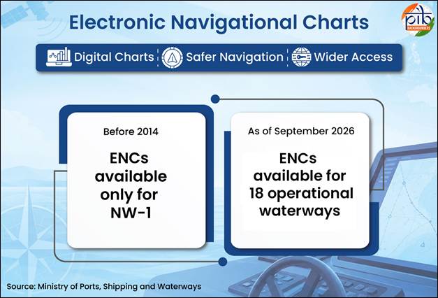
Navigation information is provided digitally to Mariners for enhanced safety through modern hydrographic charts. As of September 2026, Electronic Navigational Charts (ENCs) have been prepared for 18 operational and tidal waterways. They are uploaded on portals like PANI and IWAI Vessel Tracker. Before 2014, this facility was available only on NW-1 (the Ganga - Bhagirathi - Hooghly river system between Haldia and Prayagraj). Its expansion represents a significant widening of digitally accessible navigation information. The charts complement physical surveys by translating river information into a navigation-ready format.
PANI and IWAI Vessel Tracker: Connecting Navigation with Real-Time Information
Navigation involves more than knowing channel depth. The Portal for Asset and Navigation Information (PANI) brings river navigation and infrastructure information on a single platform. PANI provides details about National Waterways and associated assets. These include fairways, infrastructure facilities and cross-river structures. The portal also provides jetty connectivity and emergency services for facilitating transportation of cargo.
The IWAI Vessel Tracker and PANI Portal together form a web and mobile-based e-navigation system. It provides real-time vessel tracking, updated navigation routes and depth information. These features support safe and efficient movement on inland waterways.
Naudarshika: Towards Integrated River Traffic Management
Naudarshika, the National River Traffic and Navigation System, has been launched in 2025 for safe, efficient and sustainable vessel movement. The system incorporates real-time Least Available Depth (LAD) information to support navigation. Alongside existing digital platforms such as PANI and LADIS, Naudarshika adds a dedicated system for river traffic and navigation management.
River Information Services: A Traffic Information Network
River Information Services take digital navigation a step further. RIS combines vessel tracking technologies, weather and water sensors and information technology systems. It provides real-time data to vessel operators and authorities. It also supports communication between vessels and control centres. This exchange supports better traffic management and faster operational decisions.
|
RIS on the Ganga
RIS has been implemented on National Waterway-1 (Ganga) across three stretches. These are Haldia–Farakka, Farakka–Patna and Patna–Varanasi. The system includes 4 control stations and 13 base stations. It incorporates Automatic Identification System (AIS)equipment and Very High Frequency (VHF) communication. Meteorological sensors are also part of the network. RIS consoles have been provided on 30 departmental vessels. Together, these components create a real-time traffic-monitoring system along NW-1.
|
A Connected Approach to Safer Navigation
Safe navigation on India’s waterways is built on continuous knowledge, reliable infrastructure and timely information. Hydrographic surveys help understand changing river conditions, while navigation aids provide visible guidance on the water. Digital platforms are adding another layer of precision through real-time depth, route, weather and traffic information. Together, these systems are making inland navigation more predictable and responsive. As waterway traffic expands, this integrated approach helps create a stronger foundation for safe, efficient and round-the-clock vessel movement.
References
Ministry of Ports, Shipping and Waterways
https://shipmin.gov.in/en/division/iwt-1
https://shipmin.gov.in/en/content/dgll
https://shipmin.gov.in/sites/default/files/Marine%20Aids%20to%20Navigation%20Act%202021as%20Notified.pdf
https://iwai.gov.in/hydrography-0
https://dgll.nic.in/about-DGLL/Service-reminder/Buoys-page
https://www.dgll.nic.in/About-DGLL/Service-reminder/Racon
https://iwai.gov.in/offerings/national-waterway/national-waterways1
https://www.pib.gov.in/PressReleasePage.aspx?PRID=2289149®=48&lang=2
https://www.pib.gov.in/PressReleasePage.aspx?PRID=2275554®=3&lang=1
https://iwai.gov.in/least-available-depth-lad
https://www.pib.gov.in/PressReleasePage.aspx?PRID=2289149®=48&lang=2
https://iwai.gov.in/digital-platform
https://iwai.gov.in/offerings/national-waterway/national-waterways3?page=1
https://www.facebook.com/IWAI.MoPSW/videos/indias-waterways-are-entering-a-smarter-safer-and-more-connected-future-with-nau/1350068953607450/
https://www.facebook.com/IWAI.MoPSW/videos/dredging-is-the-process-of-removing-sediments-from-the-bottom-of-waterbodies-dre/1170286874124187/
https://www.pib.gov.in/PressReleasePage.aspx?PRID=2290484®=48&lang=2
https://www.pib.gov.in/PressReleasePage.aspx?PRID=2235574®=3&lang=1
https://www.pib.gov.in/newsite/PrintRelease.aspx?lang=2®=48&relid=188636
https://www.pib.gov.in/PressReleasePage.aspx?PRID=2003047&lang=2
https://www.facebook.com/IWAI.MoPSW/videos/indias-waterways-are-entering-a-smarter-safer-and-more-connected-future-with-nau/1350068953607450/
PIB Backgrounders
https://www.pib.gov.in/PressReleasePage.aspx?PRID=2255798&lang=2
Click to see pdf
***
PIB Research
(Release ID: 2324232)
Visitor Counter : 183