Ministry of Science & Technology
Recent submarine landslide in the Krishna-Godavari basin is a potential geohazard, finds NIO study
The landslide marks one of the largest underwater slope failures ever documented in the region
प्रविष्टि तिथि:
28 DEC 2024 8:10PM by PIB Mumbai
Panaji, 28.12.2024
In a groundbreaking scientific endeavour, the CSIR-National Institute of Oceanography (NIO), Goa, has reported a submarine slope failure in the Krishna-Godavari (KG) Basin, Bay of Bengal. This event poses potential risks to offshore infrastructure, submarine communication cables, and coastal communities.
The catastrophic landslide, unveiled through time-lapse geophysical data, marks one of the largest underwater slope failures ever documented in the region and highlights the critical need for monitoring deepwater geohazards.
The landslide, possibly occurred between January 2009 and December 2015, led to the erosion of approximately 160 m of sedimentary strata, displacing an estimated 11 km3 of sediments from the shelf region. The resulting fan-shaped mass transport deposit (MTD) spans about 70 km2 at depths of 950 to 1100 m, with a maximum thickness of 60 m.
The NIO scientists conducted extensive investigations to identify potential triggers. Cyclone Helen, a Category-1 storm in November 2013, emerges as a significant factor, as cyclone's eye passed directly over the head of the slumped region. Other possible contributors include extreme flooding events in the year 2010 and 2013, as well as a magnitude 6.0 earthquake in the Bay of Bengal in May 2014.
The research underscores the critical role of sediment pre-conditioning in deepwater geohazards and that even moderate triggers, such as cyclones and localized seismic activity, can lead to slope failures.
The discovery underscores the need for extended geophysical surveys and monitoring of unstable slope regions of continental margins. The findings have implications for offshore industries, emphasizing the potential for tsunami generation and infrastructure damage.
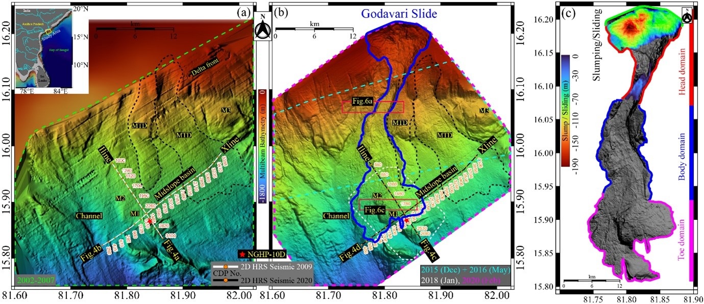
Photo Caption: 1. The figure emphasizes the recent submarine landslide, the Godavari Slide (highlighted in blue) in the Krishna-Godavari basin. An inset map provides a zoomed-out view of the study area within the Bay of Bengal. a) Multibeam bathymetric data before January 2009, b) Multibeam bathymetric data obtained after December 2015, c) difference between the baseline bathymetry and repeat survey highlighting the erosion in the KG basin.
***
PR Source by CSIR-NIO,Goa/RB/PK
Follow us on social media:  @PIBMumbai
  /PIBMumbai
  /pibmumbai
  pibmumbai[at]gmail[dot]com
(रिलीज़ आईडी: 2088636)
आगंतुक पटल : 252
इस विज्ञप्ति को इन भाषाओं में पढ़ें:
Marathi