Ministry of Science & Technology
Climate history finds monsoon fluctuation footprints from sediment transport to farming adaptations
प्रविष्टि तिथि:
16 OCT 2026 3:42PM by PIB Delhi
A new study has found that Indian Summer Monsoon fluctuations have, through the years, controlled lake hydrology, sediment transport, vegetation, sedimentary organic matter, microbial activity, and early farming adaptation in the Central Ganga Plain.
This could help strengthen climate and agricultural adaptation, guide water security and wetland conservation, enhance disaster risk reduction and advance understanding of human-climate interactions.
Scientists have been trying to address the long-standing question of how past climatic extremes influenced the evolution of human societies in the Indian subcontinent. The rise and decline of the Indus Valley Civilization have been widely linked to changes in the Indian Summer Monsoon. However, much less is known about how later communities in the Central Ganga Plain responded to similar climatic fluctuations. As one of the major centres of agricultural expansion and cultural development after the decline of the Indus Valley Civilization, the Ganga Plain provides an ideal natural laboratory to investigate long-term climate–human interactions, as multiple migrations have been recorded during 4500-1000 cal yr BP in this region.
Scientists from Birbal Sahni Institute of Palaeosciences (BSIP), an autonomous institute of the Department of Science and Technology (DST), reconstructed 4600 years of climate and environmental history by tracing palaeo-environmental conditions using proxies such as stable isotopes, vegetation changes as well as archaeological and sedimentary records from Karela Lake, an oxbow lake in Hulas Khera near Lucknow in the Central Ganga Plain.
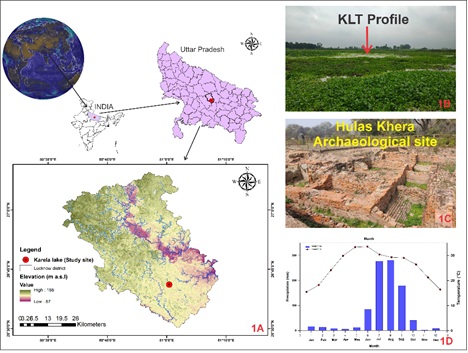
Fig. 1. (A) Study area map of the Hulas-Khera (KLT) lake, Mohanlal Ganj, Lucknow, showing the location of the lake within Uttar Pradesh. (B) Present-day view of the study site. (C) Location of the Hulas-Khera archaeological site (Kushan settlement) in close proximity to the lake. (D) Mean monthly precipitation (1901 to 2020 AD) for the Hulas-Khera region, extracted from the KNMI Climatic explorer (https://climexp.knmi.nl/start.cgi).
Sediments of the lake preserve a record of Late Holocene environmental changes. Besides, the lake's proximity to the Hulas Khera archaeological site provided opportunity to investigate how ancient agricultural communities responded to changing climatic conditions.
The study helped restructure records of hydrology, sedimentary processes, vegetation dynamics, and manure-based agricultural practices with herbivore records. Moisture records during the Little Ice Age (LIA) through westerly winds further clarified the imprints of flooding in the region during the colder phase of the LIA.
The researchers also integrated AMS-based radiocarbon chronology, stable isotopes of C and N, grain-size analysis, end-member modelling, and palynology for a more comprehensive and reliable reconstruction of climate, vegetation dynamics, hydrogeological history, and human activities than previously achieved.
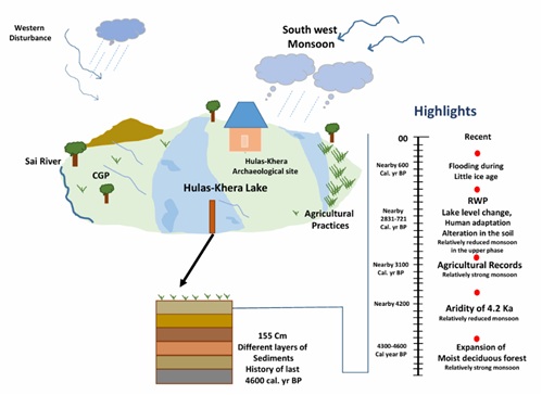
Fig. 2. Schematic view of the Karela lake (Hulas Khera) showing the climatic events and overall view of the study.
Biswajeet Thakur, Anand Rajoriya, Maneesha M ET and the radiocarbon dating laboratory team identified four major environmental phases associated with key climatic events, including the 4.2 ka arid event, the Roman Warm Period, and the Little Ice Age.
The study published in the Journal of Asian Earth Sciences integrated geochemical, isotopic, sedimentological, and biological evidence within a robust AMS radiocarbon chronology to decipher complex climate–ecosystem interactions.
It demonstrated that fluctuations in the Indian Summer Monsoon not only regulated lake hydrology, sediment transport, and shifts between C₃ and C₄ vegetation but also influenced the composition of sedimentary organic matter, its deposition pattern, microbial activities and the adaptive strategies developed by early agricultural communities in the Central Ganga Plain.
The study also established that small oxbow lakes of the Central Ganga Plain are highly sensitive natural archives capable of preserving long-term monsoon records, ecosystem evolution, and human-environment interactions, thereby providing an important baseline for understanding future environmental change in one of India's most densely populated and agriculturally important regions.
This could advance understanding of climate–human interactions and help support national climate and environmental policies by generating long-term baseline datasets essential for climate modelling, ecosystem management, land-use planning, and implementation of national priorities on climate adaptation, food security, water security, and sustainable development.
Publication link: https://doi.org/10.1016/j.jseaes.2026.107129
***
NKR/FT/AA
(रिलीज़ आईडी: 2324336)
आगंतुक पटल : 121